North Carolina, South Carolina, and Virginia Shift to Cooler Ocean Breeze Pattern Tuesday as High Pressure Brings Milder Temperatures and Coastal Winds
NORTH CAROLINA — A noticeable shift in the weather pattern is expected early next week as high pressure builds to the north, bringing an easterly ocean breeze and cooler temperatures across North Carolina, South Carolina, and Virginia by Tuesday.
High Pressure Drives Pattern Change Across the Carolinas
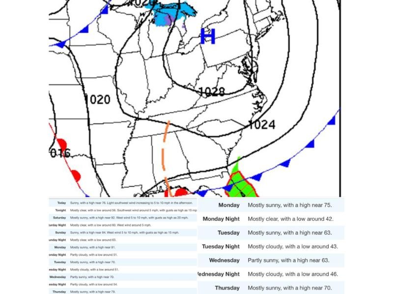
Forecast models show a strong area of high pressure centered over the Mid-Atlantic and Northeast, extending its ազդեց across the Carolinas and Virginia.
This setup replaces earlier expectations of a warmer “wedge” pattern with a more direct easterly flow off the Atlantic Ocean, changing both temperatures and overall conditions across the region.
Cooler Air Filters Inland From the Coast
As winds turn easterly, cooler marine air will begin pushing inland, especially across eastern North Carolina and coastal South Carolina.
Daytime highs are expected to drop from the mid to upper 70s earlier in the week down into the low to mid 60s by Tuesday and Wednesday, marking a noticeable but not extreme cooldown.
The cooling effect will be most pronounced closer to the coast and across higher elevations, while inland areas may see a more gradual change.
Temperature Trend Shows Gradual Cooling
Short-term forecasts indicate warm and pleasant conditions through the weekend, with highs reaching the upper 70s to low 80s under mostly sunny skies.
By Monday, temperatures remain mild, but the shift begins shortly after, with Tuesday highs falling into the low 60s, followed by similar readings into midweek.
Overnight lows will also dip into the low to mid 40s, reinforcing the cooler feel, particularly during early mornings.
Limited Moisture Despite Pattern Change
Despite the onshore flow, precipitation chances remain limited. The high-pressure system will continue to suppress widespread rainfall, resulting in mostly dry conditions.
Skies may turn partly to mostly cloudy at times, especially Tuesday night into Wednesday, but no significant rain events are currently expected.
What This Means for Residents
Residents across North Carolina, South Carolina, and Virginia can expect a comfortable but cooler stretch of weather, especially compared to the warmer conditions leading into the weekend.
The shift to an ocean-influenced pattern will bring less temperature volatility and a steadier, milder feel, particularly during daytime hours.
Final Outlook
This pattern change marks a transition toward a more stable spring setup, with high pressure and easterly winds moderating temperatures across the Carolinas and Virginia.
While not a dramatic cooldown, the difference will be noticeable, especially after recent warmer days. Stay tuned to CabarrusWeekly.com for continuing updates, and share how the changing weather is impacting your area.