Nebraska and Iowa See 40 Degree Temperature Drop After Cold Front as Fire Danger Spikes and Warmup Returns Midweek
EASTERN NEBRASKA & WESTERN IOWA — A powerful cold front has swept through the region overnight, bringing a dramatic temperature drop, gusty winds, and an elevated risk of fire danger heading into Sunday.
Sharp Temperature Drop Follows Cold Front Passage
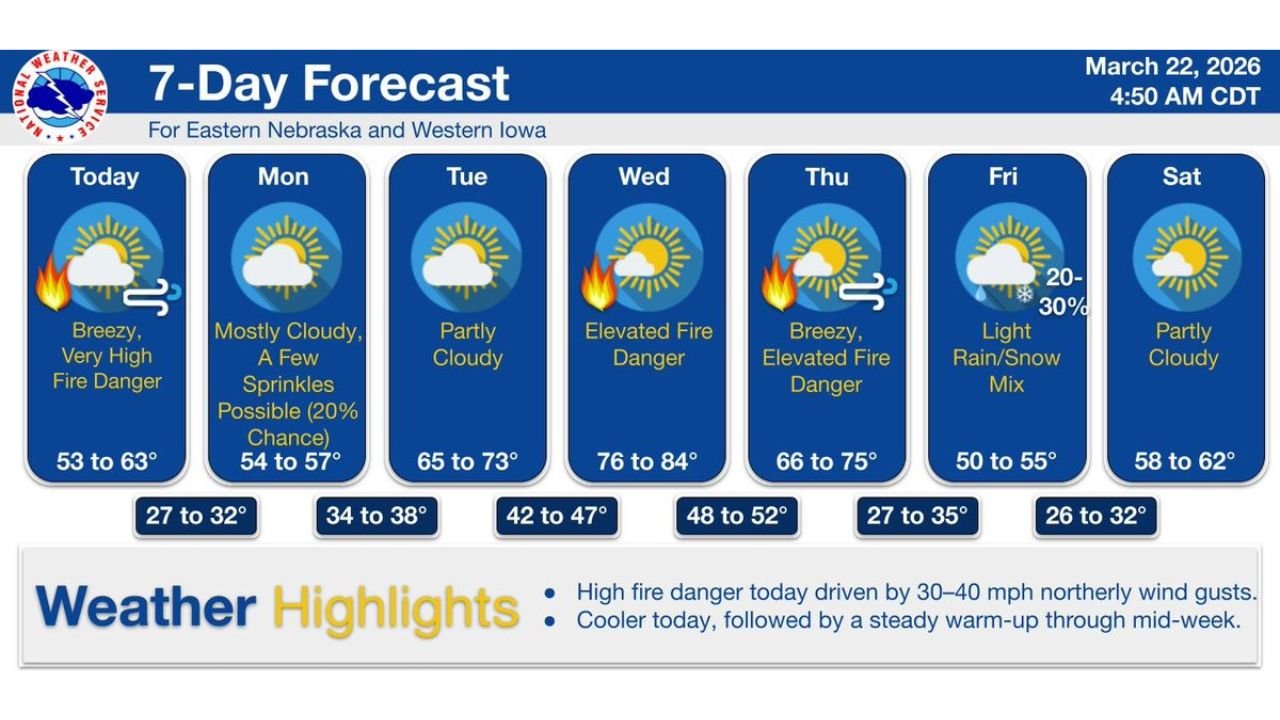
Residents across eastern Nebraska and western Iowa are waking up to a much cooler air mass, with temperatures running nearly 40 degrees colder than the previous day.
After experiencing unseasonable warmth, today’s highs are expected to remain in the low 50s to low 60s, marking a sharp and noticeable change in conditions.
This sudden cooldown is directly tied to the passage of a strong cold front that pushed through the region overnight.
Gusty Winds Creating Dangerous Fire Conditions
Behind the front, strong northerly winds gusting between 30 to 40 mph are combining with dry air to create very high fire danger across the region.
Officials warn that these conditions can allow fires to ignite easily and spread rapidly, especially in open or grassy areas.
Sunday is expected to be the most critical day, with breezy conditions and low humidity making outdoor burning particularly risky.
Early Week Brings Clouds and Slight Rain Chances
Conditions begin to stabilize slightly on Monday, with mostly cloudy skies and a slight chance (around 20%) of light sprinkles.
Temperatures will remain cool, with highs in the mid-50s, before a gradual warming trend begins.
By Tuesday, skies turn partly cloudy, and temperatures rebound into the mid-60s to low 70s, signaling the start of a more sustained warmup.
Midweek Warmup Brings Another Fire Weather Concern
The warming trend accelerates by midweek, with highs climbing into the mid-70s to mid-80s by Wednesday.
While the return of warmth may feel more comfortable, it also brings renewed fire weather concerns, particularly as dry conditions persist.
Elevated fire danger is expected to continue through at least Thursday, with breezy conditions adding to the risk.
Late Week Cooldown and Mixed Precipitation Chance
Another system arrives late in the week, bringing a cooldown and a chance for light rain or even a rain/snow mix by Friday.
Temperatures will drop back into the 50s, with overnight lows dipping into the upper 20s to low 30s, reminding residents that winter is not fully over yet.
By next weekend, conditions begin to stabilize again with partly cloudy skies and more seasonable temperatures.
What Residents Should Keep in Mind
The rapid swings in temperature and ongoing dry conditions highlight the volatile early spring pattern across the Plains.
Residents should:
- Avoid outdoor burning during high fire danger periods
- Secure loose outdoor items due to gusty winds
- Stay updated on local fire weather warnings
- Prepare for fluctuating temperatures throughout the week
This week’s forecast underscores how quickly conditions can change during March, with fire danger and temperature swings remaining key concerns.
Stay with CabarrusWeekly.com for continued updates on shifting weather patterns across the Plains and beyond.