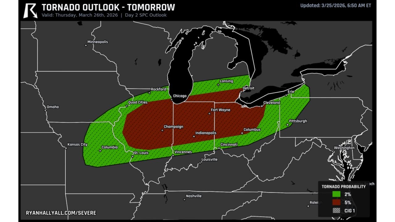
Dangerous Tornado Setup Targets Illinois Indiana Ohio and Michigan With Significant Storm Risk Thursday Night
MIDWEST AND OHIO VALLEY — A potentially dangerous severe weather setup is taking shape for Thursday, with multiple states across the Midwest and Great Lakes facing a heightened risk for tornadoes, including the possibility of a strong or significant tornado.
Tornado Threat Zone Expands Across Key States
The latest outlook highlights a broad corridor of concern stretching across:
Illinois
Indiana
Ohio
Michigan
Missouri
Pennsylvania (western parts)
Within this region, the highest tornado risk zone appears centered from central Illinois through Indiana into western and central Ohio, including major cities such as:
Chicago
Indianapolis
Fort Wayne
Columbus
Cincinnati
This corridor is where atmospheric conditions are expected to be most favorable for rotating storms.
Conditions Favor Strong Tornado Development
Meteorological signals indicate an environment capable of producing tornadoes, with some potentially becoming significant.
Key factors include:
Strong wind shear across the region
Favorable wind profiles from northern Illinois into northwest Ohio
Instability sufficient for storm intensification
These ingredients are critical for supercell thunderstorms, which are the primary producers of tornadoes.
Very Large Hail and Damaging Winds Also Likely
In addition to tornadoes, storms are expected to bring multiple severe hazards:
Very large hail up to 3 inches in diameter
Damaging wind gusts capable of causing structural damage
Frequent lightning and intense rainfall
Early storm development may produce discrete supercells, which could later evolve into clusters of storms during the evening and overnight hours.
Timing Window for Severe Weather
The threat is expected to unfold in phases throughout Thursday:
Afternoon to early evening — Initial storm development begins
Evening — Peak severe threat with supercells capable of tornadoes
Nighttime — Storms transition into clusters moving eastward
Residents across the region should remain alert, especially from late afternoon through midnight, when the most dangerous conditions are likely.
Areas of Greatest Concern
The most concerning zone for stronger storms currently includes:
Central and eastern Illinois
Much of Indiana
Western and central Ohio
Southern Michigan (including areas near Detroit)
This region aligns with the core of the tornado probability zone, where the risk for rotating storms is highest.
Final Outlook
This setup represents a serious early spring severe weather event across the Midwest and Ohio Valley, with all hazards on the table.
The combination of tornado potential, very large hail, and damaging winds makes this a situation that requires close monitoring.
Residents in Illinois, Indiana, Ohio, and Michigan should review safety plans and stay weather-aware as conditions evolve through Thursday.
Stay with CabarrusWeekly.com for continued updates as this severe weather threat develops.