Georgia Faces a High-Impact Winter Weather Threat as Cold Air Damming Sets Up Ice and Sleet Risks From North Georgia Into Metro Atlanta
United States — A high-impact winter weather setup is taking shape across north Georgia into the Atlanta metro, with forecasters increasingly focused on the role of cold air damming (CAD) in determining whether communities experience sleet, freezing rain, or plain rain this weekend. The evolving forecast remains complex, but confidence is growing that ice — not snow — could become the primary concern, especially north and east of Atlanta.
Meteorologists stress that small changes in the placement or strength of CAD could dramatically alter impacts across the region.
Cold Air Damming Will Decide Precipitation Type
Cold air damming, a common but notoriously difficult-to-model phenomenon in the Southeast, is expected to be the main source of surface-level cold air during this event. CAD occurs when cold, dense air becomes trapped east of the Appalachians, allowing freezing temperatures to persist near the ground even while warmer air flows in aloft.
This setup determines whether precipitation falls as sleet, freezing rain, or rain, and it often leads to sharp gradients in impacts over short distances.
Forecasters note that CAD is frequently underestimated at longer lead times, and even higher-resolution models can struggle with its exact depth and placement until the event is very close.
Forecast Confidence Focuses on Ice Potential
Recent changes in the 18z European (ECMWF) deterministic model runs have shifted attention almost exclusively toward CAD-driven outcomes rather than other cold air sources. These updates reinforce the idea that freezing rain and sleet may dominate the threat profile in parts of north Georgia and the metro area.
Because ice accumulation can occur quickly and affect infrastructure disproportionately, even moderate amounts could lead to dangerous travel conditions and scattered power disruptions.
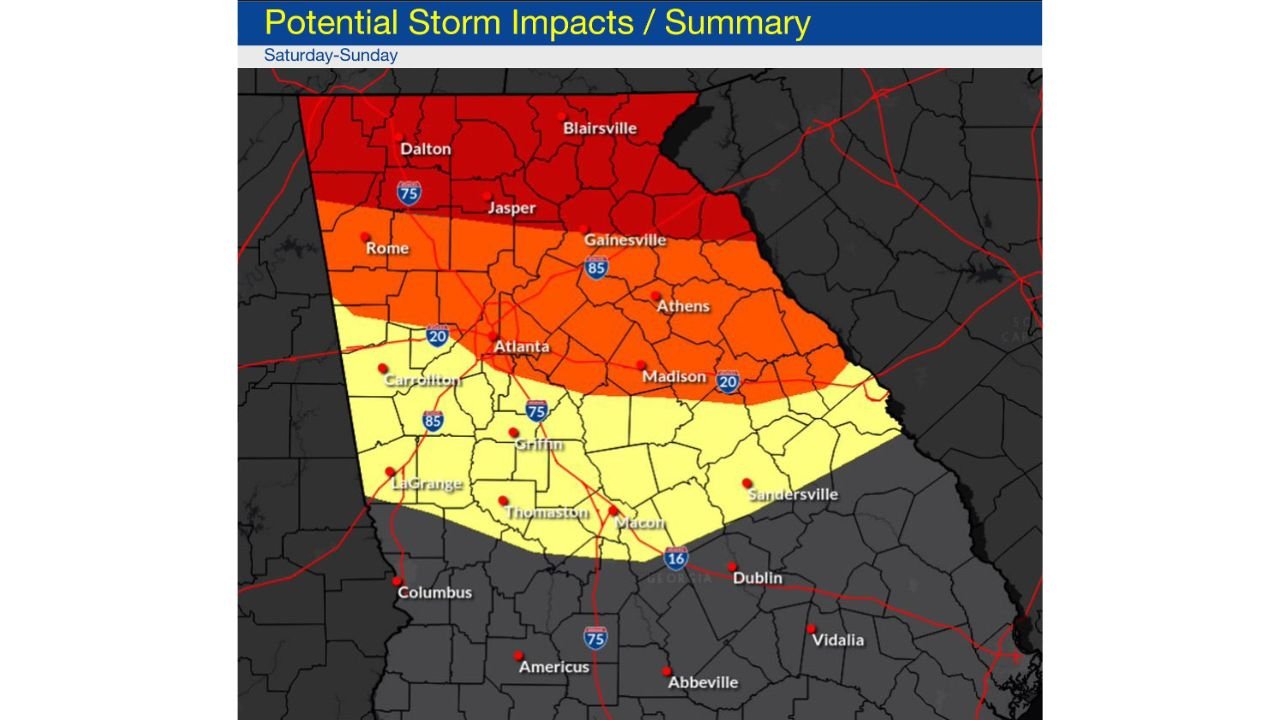
National Weather Service Highlights Areas of Concern
A graphic released by the National Weather Service Atlanta / Peachtree City office outlines three impact tiers across Georgia:
- HIGH impact areas: Accumulating snow or sleet possibly mixing with or changing to freezing rain, with significant ice or sleet accumulation and gusty winds over 30 mph at times.
- MODERATE impact areas: Considerable uncertainty, but the potential exists for 0.10 to 0.50 inches of ice accumulation, accompanied by gusty winds exceeding 20 mph. Snow potential here remains low.
- MINOR / LOW impact areas: Highly dependent on how far south the Arctic air mass advances, though there is still at least a 20% chance of freezing rain at some point during the weekend.
Why Confidence Should Improve Overnight
A reconnaissance flight into the Baja low occurred this evening, and the data collected will be ingested into the 00z (overnight) model runs. This additional sampling of the storm’s upstream environment should help improve model performance and refine expectations regarding precipitation type and impact zones.
Forecasters expect clearer guidance once this data is fully incorporated.
Timing Overview
- Primary impact window: Saturday into Sunday
- Greatest uncertainty: Precipitation type and ice placement
- Key driver: Strength and depth of cold air damming
- Potential lingering impacts: Depending on ice accumulation and temperatures
Bottom Line
This weekend’s winter weather threat for Georgia, particularly from north Georgia into the Atlanta metro, hinges on the behavior of cold air damming — a setup that can produce significant ice impacts with little warning. While uncertainty remains, confidence is increasing that freezing rain and sleet may pose the greatest risks, rather than heavy snow.
Residents should closely monitor updates, as small forecast changes could lead to major differences in local conditions.
Stay with Cabarrus Weekly for continued updates as overnight data helps clarify the evolving threat.