Texas, Oklahoma, Kansas, Missouri, Iowa, Illinois Face Growing March 30–31 Severe Storm Threat With Supercells Possible
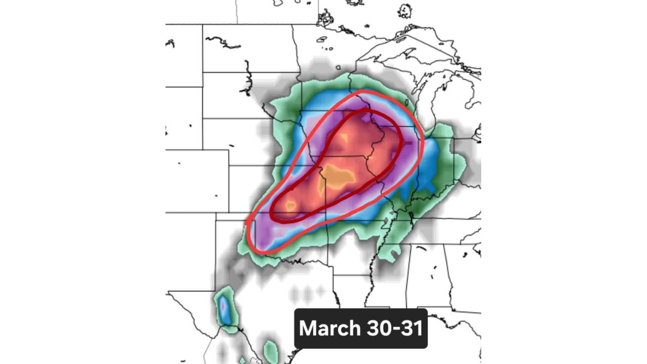
UNITED STATES — A developing weather pattern is beginning to point toward a potential multi-state severe weather event on March 30–31, stretching from the central Plains into the Midwest corn belt, with conditions favorable for organized thunderstorms and possible supercells.
While details are still being refined, the overall setup is becoming increasingly consistent for a broad corridor of storm activity.
Expanding Risk Zone From Southern Plains to Midwest
Forecast guidance highlights a growing zone of concern extending across multiple states, including:
- Texas (north), Oklahoma, Kansas
- Missouri, Iowa
- Illinois and surrounding Midwest regions
This corridor aligns with a classic early spring setup where warm, moist air surges northward and interacts with incoming disturbances from the west.
Supercell Potential Increasing Across Core Region
The latest projections suggest an environment capable of supporting supercell thunderstorms, particularly in the central portion of the risk area.
Key signals include:
- A concentrated zone of higher instability and storm organization potential
- Favorable wind patterns that can help storms rotate
- Increasing overlap of moisture, lift, and wind shear
These ingredients raise the possibility for more structured storms rather than scattered, weak activity.
Timing Focused on March 30 Into March 31
The primary window for this developing event is:
- Late March 30 (Sunday into nighttime)
- Continuing into March 31 (Monday)
This suggests a multi-round setup, where storms may initiate in the Plains and track eastward into the Midwest.
Why This Pattern Matters
This setup reflects a broader transition into a more active spring pattern:
- Systems moving out of the western U.S. into the Plains
- Increasing Gulf moisture feeding northward
- Strengthening jet stream support aiding storm development
These factors combined can lead to widespread thunderstorm development, with some storms becoming severe.
Uncertainty Still Remains
Despite the growing signal, there are still important uncertainties:
- Exact placement of the highest-risk corridor
- Timing of storm initiation and peak intensity
- How quickly storms organize into lines vs. discrete cells
Small shifts in these factors can significantly change which areas see the greatest impacts.
Early Signals Point to a Larger Pattern Shift
This potential event is not isolated. It appears to be part of a broader shift toward more frequent severe weather episodes heading into early April.
The late March timeframe often marks the beginning of more active severe weather across the central U.S., and this setup fits that seasonal trend.
Residents Urged to Monitor Updates Closely
With several days still to go, this is a situation that will continue to evolve. Those in the highlighted regions should:
- Stay updated on forecast changes
- Review severe weather safety plans
- Be prepared for possible watches and warnings as the event nears
Even though specifics are still being refined, the current pattern suggests that March 30–31 could bring a notable round of severe weather across a large portion of the country.
Stay with CabarrusWeekly.com for continued updates as confidence increases and finer details emerge.