Illinois, Iowa and Indiana Face Dual-Round Severe Storm Setup With Afternoon Tornado Risk and Evening Damaging Wind Line
ILLINOIS — A complex and potentially dangerous severe weather setup is unfolding today, with two distinct rounds of storms expected, including afternoon supercells and a later organized storm line pushing into Indiana.
First Round Targets North-Central Illinois This Afternoon
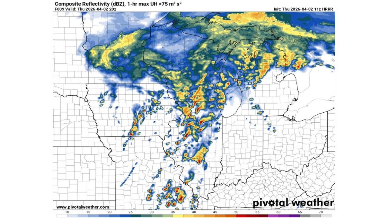
The initial wave of storms is expected to develop across north-central Illinois around 3 PM, as atmospheric conditions become increasingly unstable. This phase carries a notable tornado risk, especially where discrete supercells can form ahead of the main system.
Model data indicates storms will be scattered at first, allowing individual cells to strengthen. These supercells could produce localized rotation, damaging winds, and isolated tornadoes, particularly in areas where destabilization peaks during the afternoon hours.
Second Round Organizing Over Iowa Moving Northeast
At the same time, a second and more organized round of storms is developing across Iowa. This cluster is expected to grow into a broader system and begin moving northeast toward Illinois and eventually into Indiana.
As this second round advances, it will likely transition into a more connected line of storms, increasing the coverage of impacts. While tornado potential may become more limited in this phase, the threat shifts toward widespread damaging winds and heavy rainfall.
Storm Evolution From Supercells to Linear System
The overall pattern shows a classic evolution where initial isolated supercells transition into a larger storm line. Early storms across Illinois will have the highest tornado potential, while later activity becomes more wind-driven as storms organize.
This transition is important because it expands the impact area, bringing severe conditions to a broader region including central and eastern Illinois and into Indiana.
Evening Hours Bring Expanding Impact Into Indiana
By the evening, storms are expected to push into Indiana, including areas near Indianapolis. Although the system may weaken slightly compared to earlier supercell activity, it will still carry strong wind gusts, heavy rain, and frequent lightning.
Residents in Indiana should prepare for a decaying but still impactful storm line, capable of producing sudden wind damage and reduced visibility during heavier downpours.
Atmospheric Setup Supports Severe Storm Development
Forecast soundings and model guidance show an environment supportive of severe weather, including sufficient instability and wind shear for storm organization. This combination increases the likelihood of organized thunderstorms capable of producing multiple hazards.
While not every location will see severe conditions, areas that do experience stronger storms could see rapidly intensifying weather within a short time window.
What Residents Should Expect Through Tonight
Communities across Illinois, Iowa and Indiana should remain alert throughout the day as storms develop in phases. The afternoon brings the greatest tornado concern, while the evening shifts toward a broader damaging wind threat.
Conditions may change quickly, especially in areas where storms form earlier and intensify. Staying weather-aware will be critical as both rounds of storms move through the region.
Stay with CabarrusWeekly.com for continued updates and share what you’re seeing in your area as these storms move through today and tonight.