Iowa, Illinois and Wisconsin Face Strong Tornado Risk With Fast-Moving Supercells Targeting Davenport to Milwaukee Corridor
IOWA — A dangerous severe weather setup is expected to unfold this afternoon and evening, with a strong tornado or two possible across eastern Iowa, northwestern Illinois, and southwestern Wisconsin as fast-moving supercells develop and track northeast.
Tornado Corridor Focused Near Davenport and Quad Cities
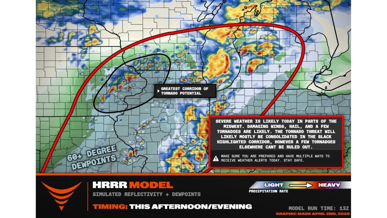
The highest tornado potential is centered around eastern Iowa, particularly near Davenport and the Quad Cities region. This area sits within a focused corridor where conditions strongly support rotating supercells capable of producing tornadoes.
Storms are expected to begin developing around 4 PM, rapidly intensifying as they organize into a cluster of supercells. These storms could produce isolated but potentially strong tornadoes, especially within the most favorable zone highlighted across eastern Iowa into northwest Illinois.
Supercells Track Northeast Toward Wisconsin by Evening
Once storms develop, they are expected to move quickly northeast into southwestern Wisconsin, including areas approaching Milwaukee later in the evening. This fast motion increases the risk of short-warning tornado situations and rapidly changing conditions.
As storms track along this corridor, communities along the path should be prepared for quickly intensifying storms capable of producing damaging winds, hail, and tornadoes.
Severe Weather Extends From Missouri to Wisconsin
The broader severe weather zone stretches from parts of eastern Missouri, including St. Louis, through Iowa City and into Wisconsin. While the highest tornado threat remains concentrated in a narrower corridor, strong to severe storms are possible across a much wider region.
Areas outside the primary tornado corridor may still experience damaging wind gusts, large hail, and intense lightning, especially as storms become more widespread.
Atmospheric Conditions Favor Strong Storm Development
High moisture levels, indicated by dew points exceeding 60 degrees, combined with favorable wind shear, are creating an environment highly supportive of severe weather. These ingredients are key drivers behind supercell formation and tornado potential.
This setup allows storms to organize efficiently and maintain strength as they move across state lines, increasing the likelihood of sustained severe impacts.
Timing and Impact Window This Afternoon and Evening
The most active period is expected from late afternoon into the evening hours, beginning near 4 PM in eastern Iowa and progressing northeast through Illinois and into Wisconsin.
Residents in the path of these storms should be prepared for rapid changes in weather conditions, including sudden wind shifts, heavy rain, and potential tornado warnings.
What Residents Should Prepare For
Communities across eastern Iowa, northwestern Illinois, and southwestern Wisconsin should stay alert as storms develop. The potential for strong tornadoes, damaging winds, and hail makes this a high-impact weather day.
Even areas slightly outside the main corridor should remain cautious, as a few tornadoes cannot be ruled out beyond the highest risk zone.
Stay with CabarrusWeekly.com for continued updates and share what you’re seeing in your area as these storms develop and move through tonight.