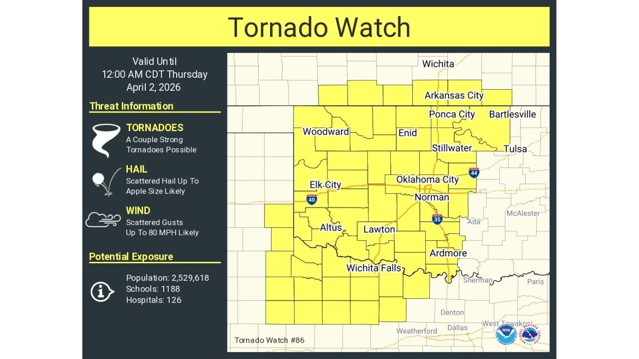
Kansas, Oklahoma and Texas Under Tornado Watch Until Midnight With Strong Tornadoes, Large Hail and 80 MPH Winds Possible
OKLAHOMA — A tornado watch has been issued across large portions of Kansas, Oklahoma, and northern Texas, where conditions are favorable for severe storms capable of producing strong tornadoes, large hail, and damaging winds through midnight CDT.
Tornado Watch Covers Major Population Areas
The watch includes a wide area across Oklahoma, extending into southern Kansas and northern Texas. Cities such as Oklahoma City, Norman, Enid, Stillwater, Lawton, Wichita Falls, and areas near Arkansas City and Ponca City are all within the watch zone.
This broad coverage indicates a large-scale environment supportive of severe storm development, with multiple rounds of storms possible.
Strong Tornadoes and Severe Hazards Possible
Storms that develop within this watch area may become intense, with the potential for a couple of strong tornadoes, especially where storms can organize and rotate.
In addition to tornadoes, the environment also supports scattered large hail up to apple size and damaging wind gusts reaching up to 80 mph, posing a threat to property and travel.
Storm Development Expected Through Evening Hours
Severe storms are expected to develop and intensify through the evening, continuing into the overnight hours until around 12 AM CDT, when the watch is currently set to expire.
As storms evolve, they may form into clusters or lines, but individual storms could still produce significant severe weather, particularly earlier in the event.
High Exposure Across the Region
This tornado watch includes a large population, with more than 2.5 million people within the affected area, along with hundreds of schools and hospitals.
This highlights the importance of preparedness, as severe weather could impact both urban and rural communities across the region.
What Residents Should Do Now
Residents across Kansas, Oklahoma, and Texas should remain alert and be prepared to act quickly if warnings are issued. A tornado watch means that conditions are favorable for tornadoes, and storms could develop rapidly.
It is important to have multiple ways to receive weather alerts and to be ready to move to shelter if conditions worsen.
Stay with CabarrusWeekly.com for continued updates and share what you’re seeing in your area as storms develop across the region tonight.