Illinois Cities Quincy, Peoria, Macomb and Bloomington Face Increasing Tornado Risk This Evening With Potential for Isolated EF2+ Storms
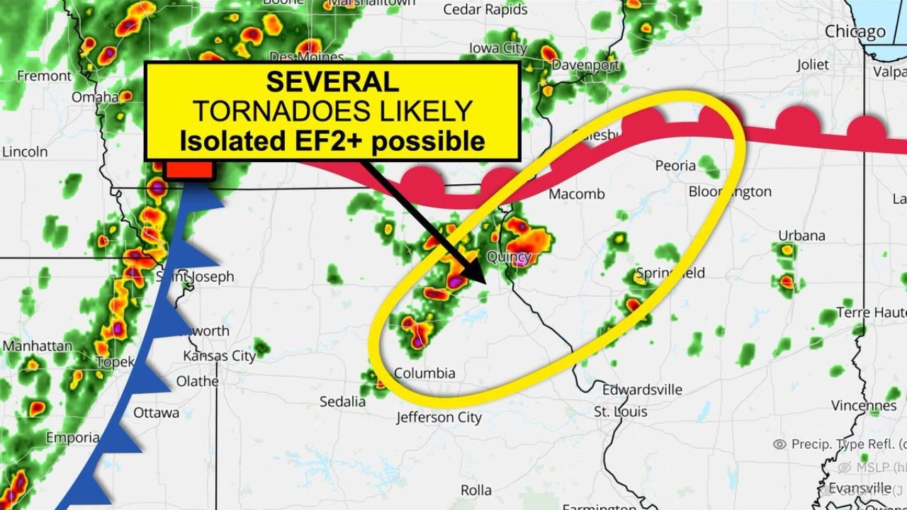
ILLINOIS — A concerning severe weather setup is developing this afternoon, with an increasing tornado risk focused across western and central Illinois between 4 PM and 8 PM, particularly impacting areas near Quincy, Macomb, Peoria, Bloomington, and west of Springfield.
Convergence Boundary Sparks Early Storm Development
Meteorological analysis shows a subtle dew point and convergence boundary stretching across western Illinois, where surface winds are colliding and creating a zone favorable for storm initiation.
This boundary is expected to act as a trigger for early storm development ahead of an approaching cold front, allowing storms to form sooner than typical frontal timing.
Supercell Storms Likely Along the Boundary
As storms begin to develop along this convergence zone, conditions in the atmosphere support rotating supercells due to changing wind speeds and directions with height.
These supercells are capable of producing stronger, more organized severe weather, especially during the late afternoon when instability peaks. Areas from northeast Missouri into western Illinois, including Quincy and Macomb, sit in a prime corridor for this development.
Tornado Risk Includes Potential for Stronger EF2+ Events
The most significant concern is the potential for tornado development along storms tracking northeast along the boundary, where they can tap into enhanced low-level spin.
Forecast signals suggest that storms moving along this boundary may ingest additional helicity, increasing the chance of rotation strengthening. This raises the possibility of isolated stronger tornadoes, including EF2+ intensity, especially in the highlighted corridor from near Quincy toward Peoria and Bloomington.
Storm Motion Enhances Risk Corridor Across Illinois
Storms are expected to move northeast along the boundary, maintaining access to favorable atmospheric conditions as they track through western into central Illinois.
This motion pattern increases the risk for multiple communities along this corridor to experience rotating storms, rather than a single isolated event.
Timing Window Critical for Severe Weather Impacts
The 4 PM to 8 PM window appears to be the most critical period for storm intensification and tornado potential. During this time, atmospheric ingredients align most effectively to support rotating storms.
Residents in Quincy, Macomb, Peoria, Bloomington, and surrounding areas should be particularly alert during these hours as storms develop and move through.
A Focused but Serious Severe Weather Setup
While this is not expected to be a widespread outbreak, the setup is highly focused and capable of producing impactful severe weather in a narrow corridor.
The combination of a convergence boundary, favorable wind dynamics, and storm motion along the boundary creates a scenario where a few storms could become particularly dangerous despite limited overall coverage.
Residents across western and central Illinois are urged to monitor weather updates closely this afternoon and evening and be prepared to act quickly if warnings are issued.
If you see storm development or severe conditions in your area, share your updates with CabarrusWeekly.com to help keep others informed during this evolving situation.