Monday Reset Timeline Across Texas, Oklahoma, and Arkansas as Calm, Dry Air Replaces Recent Severe Weather Chaos
TEXAS, OKLAHOMA, ARKANSAS — After days of active and at times severe weather across the Southern Plains, a dramatic shift is set to arrive on Monday, April 6, bringing what can only be described as a rare stretch of “perfect” weather conditions from Dallas to Oklahoma City to Little Rock.
This change marks a clear break in the pattern, offering residents a much-needed reset following recent storm activity.
From Storm Threats to Sunshine in Just Days
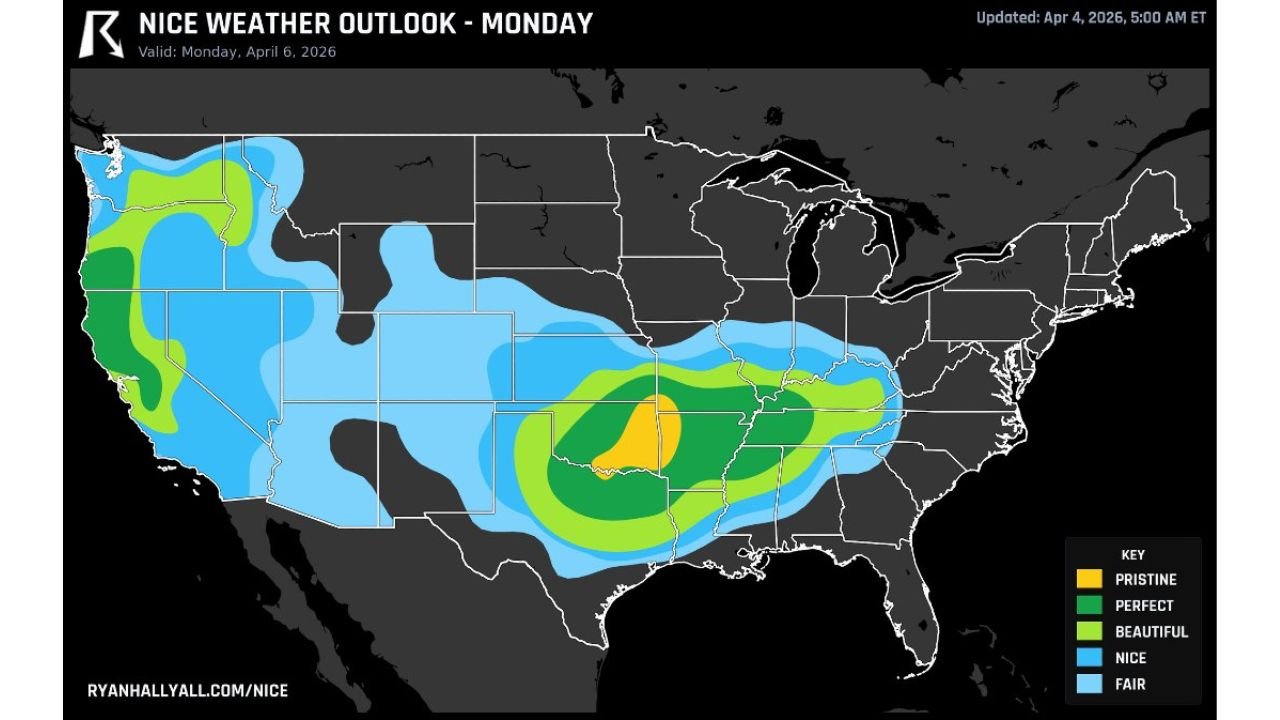
The latest outlook highlights a large zone of ideal weather conditions stretching across:
- North Texas (including Dallas)
- Central and eastern Oklahoma (including Oklahoma City)
- Arkansas (including Little Rock)
These areas fall within what is being labeled as “pristine” to “perfect” weather, the highest categories on the outlook map.
Instead of storms, the region will experience:
- Dry air dominating the atmosphere
- Clear to mostly sunny skies
- No meaningful rain chances
- Stable weather conditions throughout the day
Temperatures Settle Into Comfortable Spring Range
Temperatures across this zone are expected to land in the mid-70s, creating what many would consider ideal outdoor conditions.
This combination of:
- Mild warmth
- Low humidity
- Light winds
will make Monday stand out as one of the most comfortable weather days in recent weeks across the Southern Plains.
Why This Pattern Feels So Significant
The timing of this calm stretch is especially notable because it follows a week of repeated severe weather setups, where storms brought:
- Strong winds
- Heavy rain
- Severe thunderstorm risks across multiple states
Now, a shift in the atmospheric pattern is allowing high pressure and drier air to take control, effectively shutting down storm development—at least temporarily.
How Widespread the “Nice Weather” Zone Will Be
While the most “pristine” conditions are centered over Oklahoma and nearby regions, a broader area of “nice” to “beautiful” weather extends across:
- Much of Texas
- Portions of the Lower Mississippi Valley
- Parts of the Central U.S.
Even areas outside the core zone will still benefit from improved conditions compared to recent days, though with slightly less ideal parameters.
A True Break Before the Next Active Pattern
This calm period is not just about comfort—it’s also a critical pause in an otherwise active spring pattern.
Such breaks allow:
- Soil to stabilize after heavy rain
- Emergency services and communities to recover
- Residents to safely resume outdoor activities
However, spring patterns are rarely quiet for long, and this stretch is expected to be temporary rather than permanent.
What Residents Should Expect on Monday
For those in Dallas, Oklahoma City, Little Rock, and surrounding areas, Monday will likely bring:
- Bright skies with minimal cloud cover
- Pleasant afternoon temperatures
- Little to no wind disruption
- A complete absence of storm threats
In short, it will feel like a textbook spring day across the Southern Plains.
A Well-Timed Weather Reset Across the Region
After a turbulent stretch, this incoming pattern offers something simple but valuable: calm, predictable, and enjoyable weather.
For many across Texas, Oklahoma, and Arkansas, Monday will provide a chance to step outside and experience a true weather reset—something that has been in short supply recently.
Stay Updated With Cabarrus Weekly
For more real-time updates on shifting weather patterns, severe weather alerts, and detailed regional forecasts, stay connected with Cabarrus Weekly—your trusted source for clear and timely weather coverage across the United States.