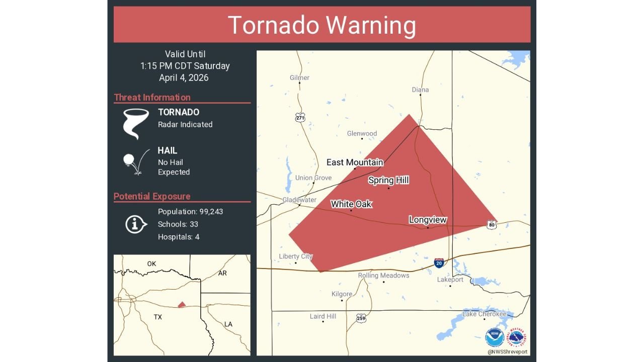
Until 1:15 PM CDT Alert Window: Tornado Warning Targets Longview, White Oak, and Clarksville City as Radar Indicates Rotation
TEXAS — A Tornado Warning is currently in effect until 1:15 PM CDT Saturday (April 4, 2026) for parts of East Texas, including Longview, White Oak, Clarksville City, Spring Hill, and surrounding communities, as radar has detected rotation capable of producing a tornado.
Warning Area and Impacted Locations
The warned zone covers a focused corridor in Gregg and Upshur County, including:
- Longview
- White Oak
- Clarksville City
- Spring Hill
- Nearby areas such as East Mountain and Union Grove
This warning polygon indicates a targeted but serious threat zone, where conditions are favorable for a tornado to develop or already be occurring.
Radar-Detected Tornado Threat
According to the warning details:
- The tornado is radar-indicated, meaning rotation has been detected by Doppler radar
- No large hail is expected with this storm
- The primary concern is a developing or ongoing tornado circulation
This type of setup can lead to rapid changes, where a tornado may form quickly with little visible warning.
Population and Infrastructure at Risk
Within the warned area:
- Nearly 100,000 residents are within the impact zone
- 33 schools and 4 hospitals are located inside the warning area
This highlights the potential for significant community impact, especially if a tornado touches down.
What Residents Should Do Immediately
If you are in Longview, White Oak, Clarksville City, or nearby areas:
- Move to a safe shelter immediately
- Go to an interior room on the lowest floor of a sturdy building
- Stay away from windows and exterior walls
- If in a vehicle or mobile home, seek stronger shelter now
Time is critical during radar-indicated tornado warnings, even if a tornado is not yet visible.
Storm Evolution Remains Uncertain
While this is not guaranteed to produce a confirmed tornado, the environment supports:
- Possible brief tornado development
- Localized damaging winds within stronger storm cores
Residents should treat this as an active and evolving situation until the warning expires or is canceled.
Stay Updated With Cabarrus Weekly
For real-time severe weather alerts, radar updates, and critical safety information, stay connected with Cabarrus Weekly—your trusted source for urgent weather coverage when it matters most.