Southern New Mexico Mountains and Far West Texas Shift to Winter Weather Advisories and a Winter Storm Warning as Weekend Snow and Ice Set In
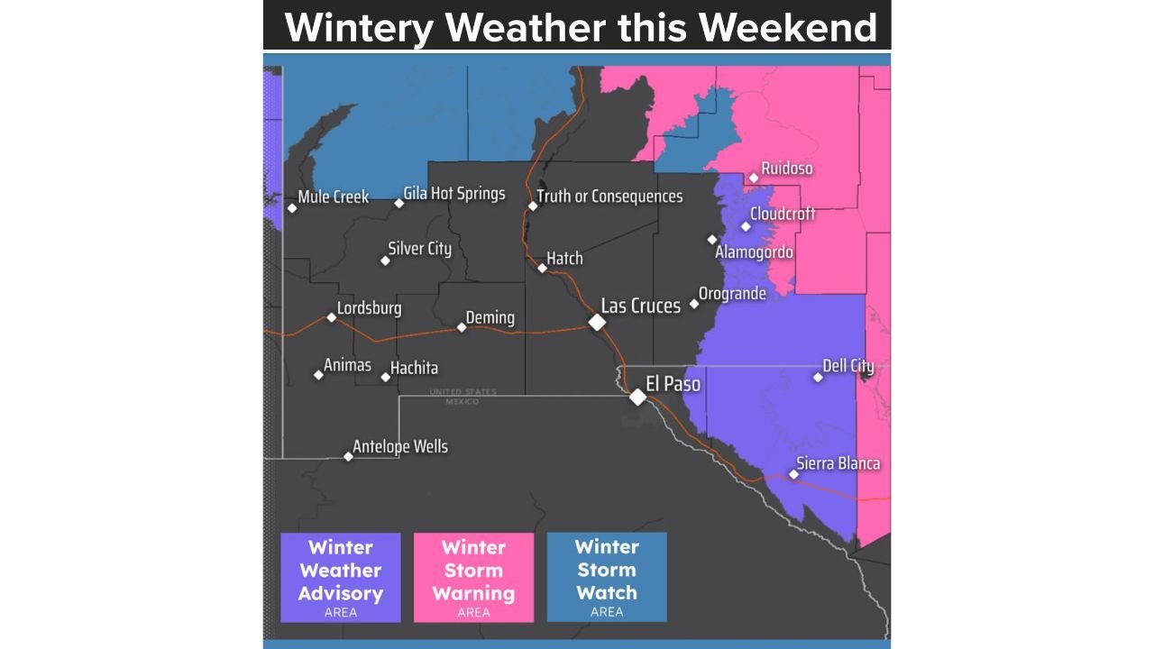
UNITED STATES — Winter Storm Watches across southern New Mexico and far West Texas have been downgraded and refined into Winter Weather Advisories and a Winter Storm Warning, as forecasters gain higher confidence in where the most impactful winter weather will occur this weekend. The latest guidance shows accumulating mountain snow and a lowland wintry mix, with the most serious conditions expected in the higher terrain and areas east of El Paso.
What Changed in the Forecast
As the system draws closer, uncertainty has decreased. Instead of broad Watches, forecasters have now issued:
- Winter Storm Warnings for the mountain zones, where confidence is highest for impactful snowfall
- Winter Weather Advisories for surrounding lower elevations, where lighter snow and ice are expected
This shift reflects a clearer picture of terrain-driven impacts, rather than a widespread plains snowstorm.
Areas Under the Greatest Threat
The highest impacts are expected Saturday morning through Sunday morning, with the following breakdown:
Sacramento Mountains
- Snow totals: 4 to 8 inches
- Heaviest snow: Along east-facing slopes and above 9,000 feet
- Impacts: Hazardous travel, snow-covered roads, reduced visibility
Otero Mesa and Hudspeth County (Including Areas East of El Paso)
- Snow: Up to 1 inch
- Additional threat: Spotty freezing rain
- Impacts: Slick roads, especially on bridges and elevated surfaces
Why This Is a Mountain-Focused Event
This storm favors higher elevations because:
- Colder air is deepest over the mountains
- Upslope flow enhances snowfall on east-facing slopes
- Moisture is limited, keeping lowland totals modest
As a result, significant accumulation will be confined to the mountains, while surrounding valleys and deserts see lighter impacts.
Travel and Safety Concerns
Drivers should be prepared for:
- Dangerous mountain travel, especially on passes and high-elevation roads
- Snowy and icy conditions overnight and early morning
- Rapid changes in road conditions with elevation
Even lower-elevation areas could experience brief icing, making untreated roads hazardous.
What Happens After the Storm
Snow and wintry precipitation should gradually taper off late Sunday, but cold air will linger, allowing icy conditions to persist in shaded and elevated locations. Any melting during the day may refreeze at night.
Residents and travelers in affected areas should closely monitor updates and plan for winter driving conditions, particularly if traveling through mountain routes.
Cabarrus Weekly will continue tracking this evolving winter setup and provide updates as advisories and warnings are adjusted.