New York, Connecticut, Massachusetts and Long Island Wake Up to Chilly 40s, Fog and Light Rain Before Cooler Showery Pattern Deepens Sunday
NORTHEAST UNITED STATES — A damp and dreary Easter Sunday is unfolding across New York, Connecticut, Rhode Island, Massachusetts, and Long Island, where temperatures have dropped into the 40s, accompanied by widespread fog and light rain early this morning.
This gray start is only part of a broader weather shift, as a cold front moves through later today, reinforcing cooler air and bringing additional rounds of rain.
Foggy and Damp Start Across the Region
Early morning conditions are marked by:
- Temperatures mostly in the low to mid-40s inland
- Slightly milder readings near the coast, especially across Long Island and southern coastal areas
- Low clouds, fog, and patchy light rain reducing visibility in some locations
The combination of moisture and cool air has created a raw, early-spring feel across much of the Northeast.
Temperatures Struggle to Recover Despite Afternoon Warm-Up
As the day progresses:
- Temperatures are expected to rise into the 50s across much of the region
- Coastal areas may remain slightly cooler due to onshore flow and persistent cloud cover
- Sunshine will be limited, keeping conditions mostly cloudy and damp
Even with some warming, the overall feel will remain cool and unsettled.
Cold Front Brings More Rain and Reinforces Cooler Air
A passing cold front will play a key role later today:
- Additional showers are expected through the afternoon and evening
- Rain coverage may increase briefly as the front moves through
- Behind the front, cooler air will settle in once again
This setup keeps the region locked into a cloudy, showery pattern rather than a quick clearing trend.
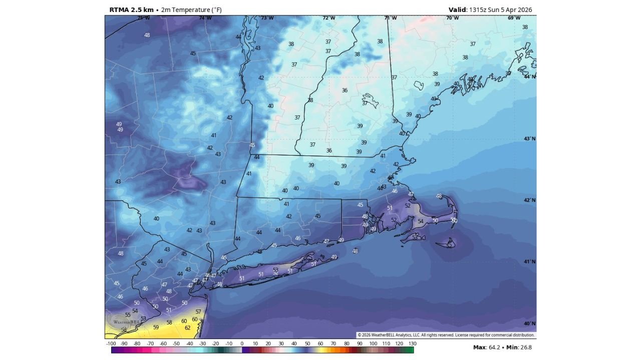
Coastal vs Inland Temperature Contrast
The temperature map highlights a noticeable gradient:
- Upper 30s to low 40s across inland New England
- Mid to upper 40s closer to the coast
- Pockets of low 50s farther south toward the Mid-Atlantic edge
This contrast is being driven by marine influence along the coast, keeping those areas slightly milder but still damp.
Overall Pattern: Cool, Wet and Slow to Improve
This Easter setup reflects a broader trend:
- Persistent moisture and cloud cover
- Cooler-than-average temperatures
- Periodic rounds of light rain and showers
There is no immediate warm-up, meaning the region will likely stay on the chilly and unsettled side through the short term.
Stay With Cabarrus Weekly for Northeast Weather Updates
As this cool and damp pattern continues across the Northeast, stay connected with Cabarrus Weekly for the latest updates on rain chances, temperature trends, and upcoming changes in the forecast.