New York, Pennsylvania, Massachusetts and Interior Northeast Could See Late-Season Snow Monday Night Into Tuesday With Minor Accumulations Possible
NORTHEAST UNITED STATES — A late-season weather twist is taking shape across the Northeast, where a surge of colder air will interact with lingering moisture to bring wet snow from Monday night into early Tuesday, especially across interior areas.
While this is not expected to be a major snowstorm, the setup is notable for April and could still create minor travel impacts and localized delays.
Where Snow Is Most Likely to Develop
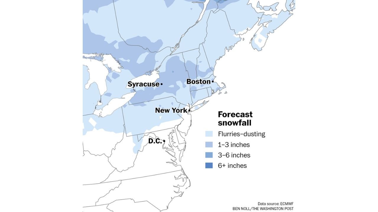
The highest chances for accumulating snow are expected across:
- Interior Pennsylvania
- Upstate New York, including areas near Syracuse
- Interior New England, including parts of Massachusetts and surrounding states
Major coastal cities like New York City and Boston may see little accumulation, with precipitation more likely to fall as a mix or light snow with minimal impact.
Expected Snow Amounts Across the Region
Current projections suggest:
- Flurries to a light dusting in many areas
- 1 to 3 inches possible across interior zones
- Isolated pockets could see 3 to 6 inches, mainly in higher elevations
The snow will be wet and heavy in nature, limiting widespread accumulation but still capable of briefly coating surfaces.
Timing of the Snow Event
- Monday Night: Rain begins to transition to snow from west to east as temperatures drop
- Overnight into Early Tuesday: Peak window for snow showers and light accumulation
- Tuesday Morning: Snow tapers off, but lingering impacts may remain during the morning commute
Because temperatures will hover near freezing, accumulation will depend heavily on elevation and intensity of snowfall.
Potential Impacts: Minor but Notable
Even though this is a lower-end event, a few impacts are possible:
- Scattered school delays, especially in interior regions
- Brief slick spots on roads, particularly early Tuesday
- Reduced visibility during heavier snow bursts
Most areas will avoid major disruption, but the timing during the early morning hours could still affect travel.
A Reminder That Winter Isn’t Fully Gone Yet
This event highlights how early April can still deliver wintry surprises, especially when cold air lingers behind recent storm systems.
The combination of cold temperatures and leftover moisture is enough to squeeze out one more round of snow before more typical spring warmth returns.
Stay With Cabarrus Weekly for Northeast Weather Updates
For continued updates on late-season snow, temperature swings, and changing spring patterns, stay connected with Cabarrus Weekly for accurate and timely weather coverage across the United States.