Kansas and Nebraska Targeted for Destructive Hail Event Today With Supercells Capable of Producing 2+ Inch Stones Along Warm Front
KANSAS, NEBRASKA — A dangerous hail-producing storm setup is expected to develop today across parts of the Central Plains, where atmospheric conditions are aligning for very large and potentially destructive hail.
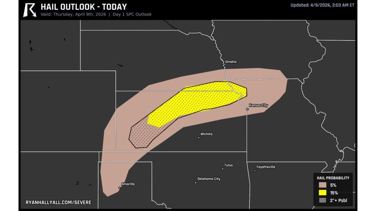
Central and Northeast Kansas Into Southeast Nebraska at Highest Risk
The primary risk area extends from central and northeast Kansas into southeast Nebraska, where the environment is most favorable for severe thunderstorm development.
Within this corridor, conditions support hail exceeding 2 inches in diameter, which is capable of causing significant damage to vehicles, roofs, and crops.
Supercell Storms Likely to Develop This Afternoon
Storms are expected to initiate during the afternoon hours along a warm front, which will act as the key boundary for storm formation.
As storms develop, they are likely to become supercells, the type of storm most capable of producing extremely large hail and organized severe weather.
Atmospheric Setup Strongly Supports Giant Hail Formation
The environment across the region features steep lapse rates and strong wind shear, both of which are critical ingredients for large hail production.
These conditions allow storm updrafts to become very strong, keeping hailstones suspended in the storm longer and allowing them to grow to very large sizes before falling to the ground.
Potential for Some of the Largest Hail in Recent Events
Forecast signals suggest that storms today could produce some of the largest hail seen in recent setups across this region, especially in areas where storms remain isolated and intensify quickly.
The combination of instability and storm structure increases the risk for significant hail damage within localized areas.
Additional Risk Extends Into Oklahoma and Texas Panhandle
Beyond the highest risk zone, surrounding areas including southwest Kansas, the Oklahoma Panhandle, and parts of the Texas Panhandle may also see severe storms.
In these areas, storms may form as clusters, still capable of producing large hail and damaging winds, though the highest-end hail threat remains farther north.
Timing and Safety Considerations
The most dangerous period is expected from mid-afternoon through early evening, when storm intensity peaks.
Residents in Kansas and Nebraska should remain alert for rapidly developing storms and be prepared to take action if warnings are issued, especially given the potential for very large hail capable of causing sudden damage.
Stay with CabarrusWeekly.com for continued updates, and share what conditions you are seeing in your area as severe storms develop today.