Dryline Setup Across Southern Plains Sunday April 12 Brings Severe Storms Likely Afternoon With Damaging Wind Gusts Large Hail And Tornado Risk Across Oklahoma City Wichita Wichita Falls Abilene And Dallas Corridor
UNITED STATES — A classic and common storm setup is taking shape across the Southern Plains for Sunday afternoon, April 12, 2026, as a well-defined dryline boundary pushes through the region, creating prime conditions for severe thunderstorm development across a corridor stretching from Kansas through Oklahoma and into North Texas.
What Is A Dryline And Why Does It Matter Sunday
A dryline is a boundary that separates moist air on the eastern side from dry desert air on the western side. This type of boundary is one of the most common and potent triggers for severe storm initiation across the Plains, and Sunday’s setup fits that pattern well.
On Sunday, this dryline will work its way across the Southern Plains during the afternoon hours, with moist tropical air surging in from the Gulf of Mexico to the east colliding directly against dry desert air pushing in from the west. This clash of air masses creates the instability and lift needed to fire severe thunderstorms along the boundary.
Storm Development Area And City By City Storm Probabilities
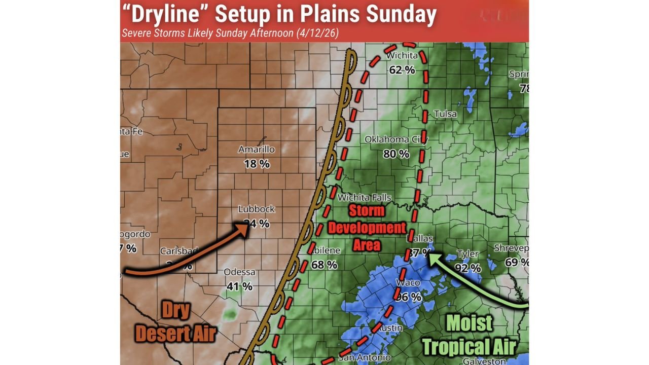
Forecast data from BAM Weather pinpoints a clear Storm Development Area running through the heart of the Southern Plains Sunday afternoon. Storm probability percentages across key cities highlight exactly where the greatest risk lies:
- Oklahoma City, Oklahoma — 80% storm probability — sitting directly within the primary storm development zone
- Wichita, Kansas — 62% — elevated risk as the dryline extends northward
- Abilene, Texas — 68% — well within the storm initiation corridor
- Tyler, Texas — 92% — extremely high storm probability on the eastern moist air side
- Dallas, Texas — 37% — potential for storm activity as the boundary pushes through
- Waco, Texas — 66% — significant storm chances with moist tropical air in place
- Odessa, Texas — 41% — lower but non-zero chances on the drier western fringe
- Amarillo, Texas — 18% — marginal risk farther west in the dry air zone
The highest storm probabilities are concentrated along and east of the dryline, where moist tropical air from the Gulf is deepest and most unstable.
Primary Severe Weather Hazards Sunday Afternoon
Should storms develop along the dryline as expected Sunday afternoon, three main hazards are associated with this particular setup:
- Damaging Wind Gusts — capable of downing trees, power lines, and causing structural damage
- Large Hail — a significant threat with any supercell storms that develop along the boundary
- Tornadoes — cannot be ruled out as the dryline interacts with strong wind shear and instability across the region
This combination of hazards makes Sunday afternoon a dangerous window for anyone living across the Southern Plains storm development corridor.
Timing And What To Expect Sunday
The primary window for severe storm development will be Sunday afternoon into the early evening hours as daytime heating maximizes instability along the dryline. Residents across Oklahoma, Kansas, and North Texas should be prepared for conditions to deteriorate quickly once storms begin firing.
Key points to keep in mind heading into Sunday:
- Storms are likely to develop rapidly once daytime heating peaks in the afternoon
- The storm development corridor runs from southern Kansas through central Oklahoma and into North Texas
- Conditions to the east of the dryline — where moist tropical air is deepest — carry the highest overall storm probabilities
- Storms that become organized could produce all hazards simultaneously including wind, hail, and tornadoes
Stay Weather Aware Across The Southern Plains Sunday
Residents across Oklahoma City, Wichita, Wichita Falls, Abilene, Dallas, and surrounding communities should remain weather aware throughout Sunday afternoon and evening. Have a severe weather plan ready, know your shelter location, and keep a close eye on local warnings as conditions evolve.
Stay with CabarrusWeekly.com for continued coverage of this developing severe weather threat across the Southern Plains as Sunday’s storm setup unfolds.