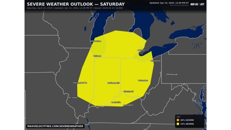
Tuesday’s Threat Is Real: Damaging Winds, Very Large Hail, and Tornadoes Possible from Texas to Michigan as the Midwest Eyes a Potentially Significant Severe Weather Day
UNITED STATES — A significant severe weather day is shaping up for Tuesday, April 14, 2026, with a corridor of dangerous storms expected to stretch from Texas all the way north to Michigan. Damaging winds, very large hail, and a few tornadoes are all on the table, and forecasters are already eyeing the Midwest as the area with the most heightened threat — with the possibility of risk upgrades still to come.
A Long and Dangerous Corridor Is Taking Shape for Tuesday
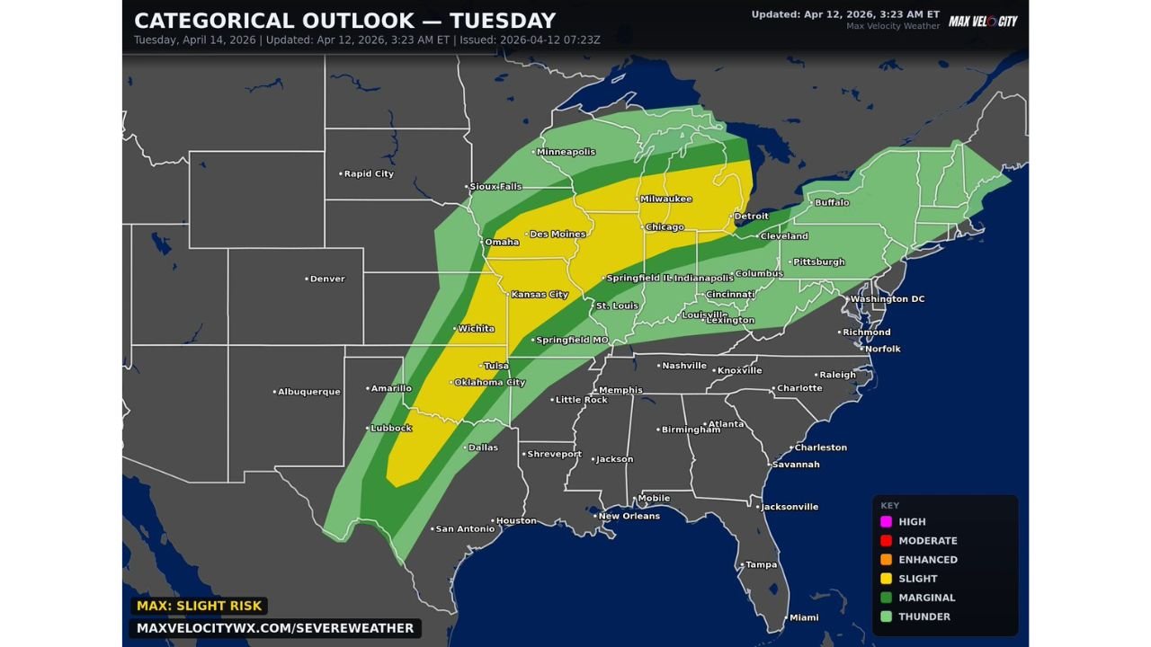
The categorical outlook for Tuesday, updated April 12, 2026 at 3:23 AM ET, shows a well-defined severe weather corridor cutting through the heart of the country. The threat is not isolated to one city or one state — it runs along a long north-to-south axis covering a large portion of the central and eastern United States.
The current maximum risk on the map is a Slight Risk, but that label does not fully capture what this setup could become. Forecasters are watching closely for upgrades as the event draws closer.
Risk Zones for Tuesday April 14
| Risk Level | Cities and Areas Covered |
|---|---|
| Slight Risk — Level 2/5 | Dallas, Wichita, Oklahoma City, Tulsa, Kansas City, St. Louis, Springfield MO, Des Moines, Omaha, Chicago, Milwaukee, Indianapolis, Springfield IL |
| Marginal Risk — Level 1/5 | Lubbock, Amarillo, San Antonio, Houston, Shreveport, Little Rock, Memphis, Nashville, Louisville, Lexington, Cincinnati, Columbus, Cleveland, Detroit, Pittsburgh, Minneapolis, Sioux Falls, Buffalo |
| Thunder Risk | Broader surrounding areas including parts of the Southeast and Northeast |
The Slight Risk zone forms the core of Tuesday’s threat, running from northern Texas through the Plains and into the Great Lakes. The Marginal Risk zone fans out widely on both sides, pulling in cities from Houston in the south to Buffalo and Minneapolis in the north.
The Midwest Is the Area to Watch Most Closely
While the entire corridor carries a severe weather threat, forecasters are specifically highlighting the Midwest as the zone of most heightened concern. Wind shear and other atmospheric parameters are expected to be very high across this region on Tuesday, creating an environment that strongly supports supercell development.
Cities including Chicago, Milwaukee, Detroit, Indianapolis, Columbus, and Cleveland sit within or near this elevated threat area. If supercells become likely in the Midwest, risk upgrades in future outlooks are possible — meaning the current Slight Risk designation may not be the final word on how serious Tuesday becomes.
What Kind of Storms Are We Talking About
This is not a garden-variety thunderstorm threat. The hazards expected from any storms that develop Tuesday include:
- Damaging winds capable of causing widespread destruction across the corridor
- Very large hail as a primary and significant threat throughout the Slight Risk zone
- A few tornadoes possible, particularly in areas where supercells can sustain themselves
- All hazards are on the table for the Midwest where wind shear values are highest
The combination of damaging winds, very large hail, and tornado potential across a corridor this wide — from Texas to Michigan — makes Tuesday a day that demands attention well in advance.
Cities That Need to Be Paying Attention Right Now
From south to north, the list of cities sitting inside or immediately adjacent to the threat zone on Tuesday is extensive:
Texas and Southern Plains: Dallas, Wichita, Lubbock, Amarillo, Oklahoma City, Tulsa
Mid-South and Lower Midwest: Kansas City, St. Louis, Springfield MO, Little Rock, Memphis
Upper Midwest and Great Lakes: Des Moines, Omaha, Chicago, Milwaukee, Minneapolis, Detroit, Cleveland, Indianapolis, Columbus
East: Pittsburgh, Louisville, Lexington, Cincinnati, Buffalo
Residents across all of these areas should be monitoring the forecast closely over the next 48 hours as confidence in Tuesday’s setup continues to build.
The Bottom Line Heading Into Tuesday
A significant severe weather event is possible across a long stretch of the country on Tuesday, April 14. The Midwest carries the most elevated risk given the very high wind shear values expected there, and upgrades to the current outlook remain on the table as the event gets closer.
The current maximum risk is Slight — but this setup has the ingredients to become something more serious, particularly if supercells develop and sustain themselves across the high-shear Midwest environment. Tuesday is a day to take seriously from Texas to Michigan.
Stay with CabarrusWeekly.com for ongoing updates on Tuesday’s severe weather threat, including any risk upgrades, watches, and warnings as they are issued across the corridor.