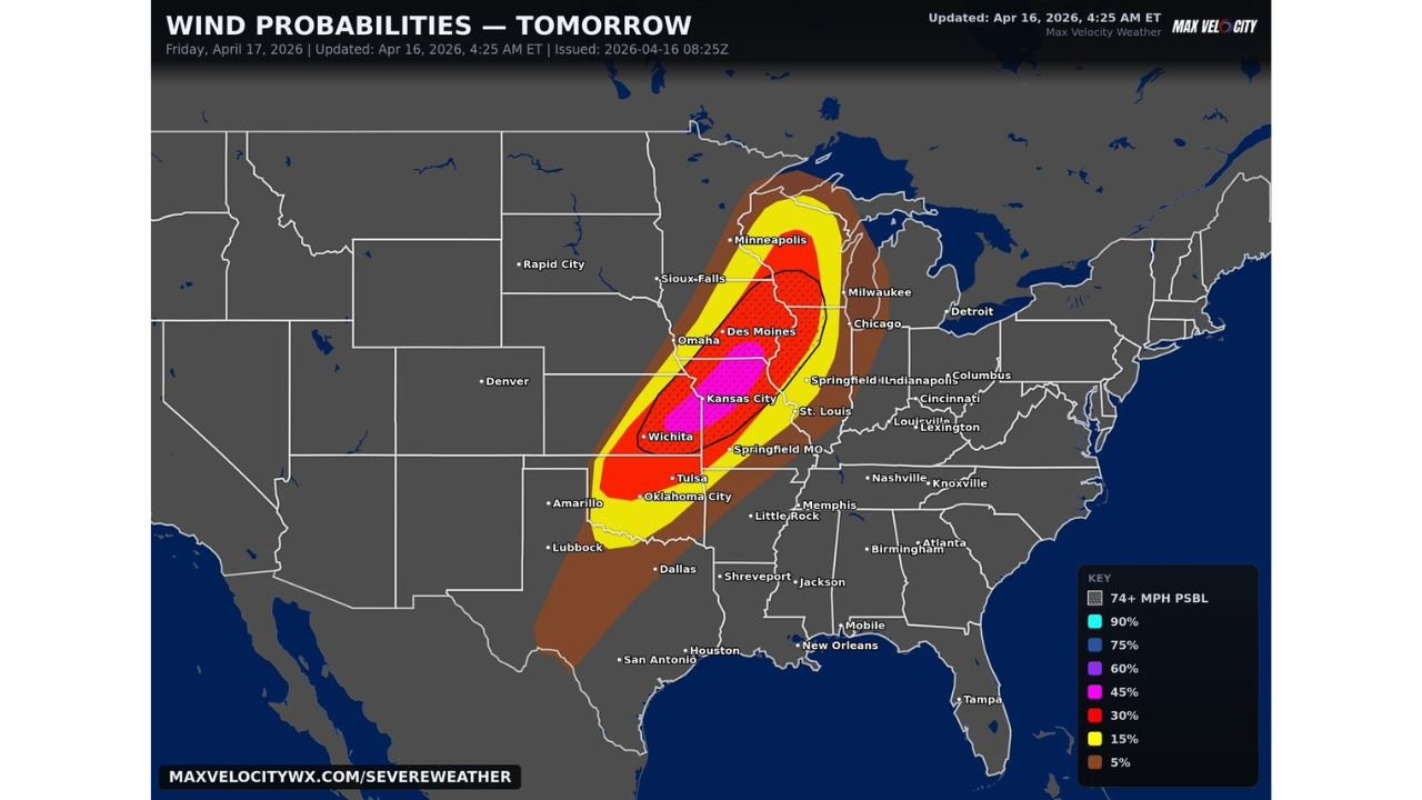
Kansas City Faces 60 to 85 MPH Damaging Winds Friday as a Very Significant Wind Threat Targets the Plains and Midwest With Tornadoes and Large Hail Also Possible
KANSAS CITY, MISSOURI — Friday April 17, 2026 is shaping up as a very dangerous wind event for the Plains and Midwest. A 45% probability of damaging winds is centered directly on Kansas City and surrounding areas, with widespread gusts of 60 to 85 mph likely across the core threat zone. Tornadoes and very large hail are also possible on top of the wind threat, making Friday one of the most serious severe weather days of the year.
Wind Probability Zones for Friday
| Probability | Cities Covered |
|---|---|
| 45% damaging winds | Kansas City, Wichita core zone |
| 30% | Des Moines, Omaha, Tulsa, Oklahoma City |
| 15% | Minneapolis, Sioux Falls, Springfield MO, St. Louis |
| 5% | Chicago, Milwaukee, Amarillo, Dallas outer zone |
| 74 mph or higher possible | Hatched zone across Kansas City and Wichita corridor |
The 45% probability zone is centered on Kansas City and Wichita — meaning nearly a 1 in 2 chance of damaging wind gusts in those cities Friday. The 74 mph or higher wind zone overlaps directly with the highest probability area.
What 60 to 85 MPH Winds Actually Do
Gusts in the 60 to 85 mph range are capable of snapping large trees, collapsing power lines across wide areas, causing structural damage to buildings, and making driving in any vehicle extremely dangerous. This is not a routine thunderstorm wind event — this is a potentially destructive and widespread damaging wind outbreak for the Kansas City and surrounding corridor.
Tornadoes and very large hail on top of this wind threat mean Friday carries all severe hazards simultaneously across the Plains and Midwest.
Get indoors before storms arrive Friday. Secure all outdoor property today. Keep alerts active through the overnight hours.
Stay with CabarrusWeekly.com for live Friday wind and severe weather coverage across the Plains and Midwest.