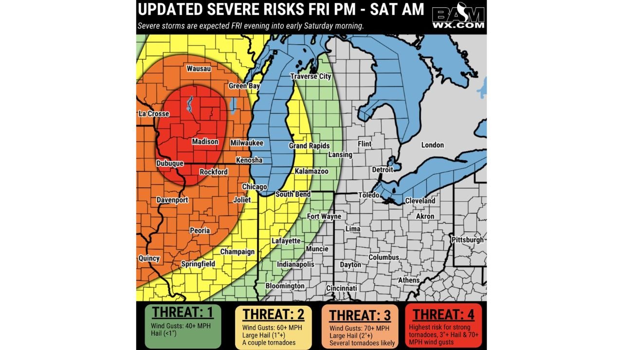
Northeast Iowa and Southern Wisconsin Upgraded to Highest Threat as 3 Inch Hail, 70 MPH Winds and Strong Tornadoes Target La Crosse, Madison and Dubuque Friday Evening
NORTHEAST IOWA AND SOUTHERN WISCONSIN — The risk has been upgraded this morning for northeast Iowa and southern Wisconsin after forecasters identified increased strong tornado potential for the region. Severe storms initiate this afternoon in the Central Plains before organizing into a line and pushing southeast through Friday evening into early Saturday morning.
Four Threat Levels — Know Where You Stand
| Threat Level | Wind | Hail | Tornado | Cities |
|---|---|---|---|---|
| Threat 4 — Highest | 70+ MPH | 3 inch+ | Strong tornadoes | La Crosse, Madison, Dubuque, Rockford |
| Threat 3 | 70+ MPH | 2 inch+ | Several likely | Wausau, Green Bay, Milwaukee, Kenosha, Chicago, Joliet, Davenport |
| Threat 2 | 60+ MPH | 1 inch+ | A couple possible | Grand Rapids, Kalamazoo, South Bend, Fort Wayne, Indianapolis, Peoria |
| Threat 1 | 40+ MPH | Under 1 inch | None specified | Lansing, Detroit, Toledo, Cleveland, Columbus, Cincinnati |
The Upgraded Zone Is the Most Dangerous Tonight
La Crosse, Madison, Dubuque, and Rockford sit inside the Threat 4 bullseye — the highest risk zone on the map. 3 inch hail, 70 plus MPH winds, and strong tornadoes are all expected in this zone Friday evening. This is a life-threatening severe weather situation for these communities.
Storms push southeast through the evening — meaning the threat arrives later for Chicago, Indianapolis, and the broader Ohio Valley.
Get underground before storms arrive. Keep alerts active through Saturday morning.
Stay with CabarrusWeekly.com for live Friday severe weather updates across Iowa, Wisconsin, and the Great Lakes.