Southern Plains Tornado and Severe Weather Threat Surges Back Thursday Through Friday Across Oklahoma to Arkansas
UNITED STATES — A developing trough-ridge pattern across the United States is setting the stage for a multi-day return of severe weather and tornado potential across the Southern Plains and Mid-South, with organized threat areas now outlined for both Thursday April 23 and Friday April 24 as peak storm season takes hold.
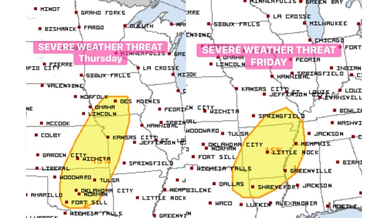
Thursday’s Threat Covers Wichita to Oklahoma City and Tulsa
Thursday’s severe weather risk zone carves out a concentrated corridor across the central and southern Plains, with the primary threat area covering Wichita, Garden City, Liberal, Woodward, Oklahoma City, Norman, Tulsa, and Kansas City. The risk zone extends northward toward Des Moines and Lincoln and includes a broader marginal area pushing toward Hannibal and Springfield.
The Southern Plains — particularly Oklahoma and southern Kansas — are highlighted as the most active zone for Thursday, with tornado potential embedded within the overall severe threat.
Friday’s Zone Shifts Into Oklahoma, Texas and Arkansas
By Friday, the severe weather corridor shifts eastward and slightly southward, with the enhanced risk area now centered across Oklahoma City, Norman, Fort Sill, Wichita Falls, Dallas, Tulsa, and Little Rock. The Friday zone also expands into portions of Arkansas, northern Texas, and the western Mid-South, with Shreveport, Greenville, and Jackson all falling within the broader threat area.
| Day | Core Threat Cities | Broader Risk Zone |
|---|---|---|
| Thursday Apr 23 | Wichita, OKC, Tulsa, Kansas City | Des Moines, Lincoln, Springfield |
| Friday Apr 24 | OKC, Dallas, Wichita Falls, Little Rock | Shreveport, Jackson, Greenville |
Tornado Potential Continues Through End of April
Beyond this week’s two-day event, long-range guidance continues to signal the southern Plains remaining active for severe weather and tornado potential through the end of April. The trough-ridge pattern locking into place is a classic driver of prolonged severe weather setups during peak spring storm season, meaning additional rounds of storms are likely beyond just Thursday and Friday.
Southern Plains Waking Up for Storm Season
The pattern evolution underway represents the southern Plains fully entering peak severe weather season, with back-to-back significant severe weather events now on the books within a matter of days. Residents across Oklahoma, Kansas, Texas, and Arkansas should treat this as the beginning of an extended period of elevated severe weather vigilance through the remainder of April.
Stay with CabarrusWeekly.com for live tornado and severe weather updates across the Southern Plains and Mid-South through the end of April.