April Snow Sweeps Michigan and Northeast Ohio Tonight With Up to 3 to 5 Inches and Slick Roads Into Monday Morning
MICHIGAN — An unseasonable round of April snowfall is moving through Michigan and into northeastern Ohio tonight, with accumulations of 1 to 5 inches possible across the Great Lakes region and isolated slick spots threatening roads and bridges overnight into Monday morning April 20.
Snow Blankets Michigan From the Upper Peninsula to the Lower Peninsula
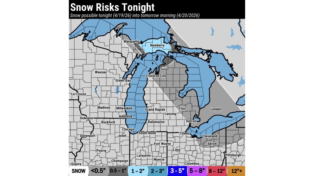
Snow risk mapping valid tonight April 19 into April 20, 2026 shows the heaviest accumulation zone concentrated across northern and central Michigan, with the Upper Peninsula and areas around Marquette, Newberry, Traverse City, and the northern Lower Peninsula sitting in the 3 to 5 inch accumulation zone.
Across the southern Lower Peninsula, including Grand Rapids, Lansing, Kalamazoo, and Flint, accumulations are expected in the 1 to 2 inch range with locally higher totals possible in favored lake-effect corridors. The Detroit metro area sits on the lighter southern fringe of the snow shield, with less than 0.5 to 1 inch likely.
Northeast Ohio Also Clipped by Snow Tonight
The snow threat extends southeastward into northeastern Ohio, with Cleveland, Akron, and Toledo all falling within the light snow accumulation zone. Totals in this area are expected to remain under 0.5 to 1 inch, but isolated slick spots on bridges, overpasses, and untreated surfaces remain a concern overnight.
| Region | Expected Snow Accumulation |
|---|---|
| Northern UP and Marquette area | 3 to 5 inches |
| Traverse City and northern Lower MI | 2 to 3 inches |
| Grand Rapids, Lansing, Kalamazoo | 1 to 2 inches |
| Detroit metro | Less than 0.5 inches |
| Cleveland, Akron, Toledo OH | 0.5 to 1 inch |
Slick Spots the Primary Concern Overnight Into Monday
While total accumulations remain relatively light across most areas, isolated slick spots are the primary overnight hazard — particularly on elevated surfaces, bridges, and secondary roads where temperatures drop quickest. Early Monday morning commuters across Michigan and northeastern Ohio should allow extra travel time and watch for patchy icy conditions before temperatures rise through the morning hours.
Stay with CabarrusWeekly.com for live snow accumulation and road condition updates across Michigan and northeastern Ohio tonight.