Florida Faces Scattered Severe Storms With Large Hail, Gusty Winds and Brief Tornado Possible From Orlando and Tampa to Miami and West Palm Beach Tuesday May 12 This Afternoon and Evening
ORLANDO, Florida — Scattered strong to severe storms are possible across Florida this afternoon and evening, Tuesday, May 12, 2026, with the greatest storm coverage expected along the east coast from St. Augustine and Melbourne south through West Palm Beach and Miami.
Some storms will be capable of frequent lightning, larger hail, gusty winds and a brief spin-up tornado cannot be ruled out anywhere across the state through the 4:00 PM to 8:00 PM timeframe.
Where Storms Are Most Likely
The threat zone covers a broad area of Florida with higher coverage on the east side of the state:
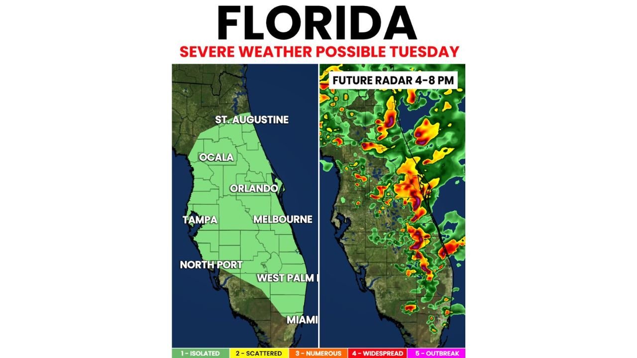
- St. Augustine and Ocala sit near the northern end of the primary threat zone, where scattered storms will be possible during the afternoon and evening hours Tuesday, May 12.
- Orlando and Melbourne fall within the heart of the east coast storm corridor, where future radar shows the heaviest and most intense storm activity between 4:00 PM and 8:00 PM.
- Tampa and North Port on the west coast of Florida still face storm chances this afternoon and evening, though storm coverage and rainfall totals will be lower than along the east coast.
- West Palm Beach and Miami are included in the afternoon and evening storm threat, with the future radar showing active storm cells pushing through the southern Florida peninsula during the 4:00 PM to 8:00 PM window.
What These Storms Could Produce
Any storm reaching severe levels across Florida this afternoon and evening could produce three primary threats:
- Larger hail is possible with the strongest storm cells developing across Florida this afternoon, particularly along the east coast corridor from Melbourne south toward West Palm Beach and Miami.
- Gusty winds capable of knocking down tree branches and causing isolated power outages are possible with any severe storm that develops across the state through the evening hours.
- A brief spin-up tornado cannot be ruled out anywhere within the threat zone from Ocala and Orlando south through Miami, though the overall tornado threat remains low. Spin-up tornadoes can develop quickly with little warning and are one of the most dangerous aspects of scattered Florida storm events.
East Coast vs West Coast Coverage
Storm coverage and rainfall totals will not be equal across Florida this afternoon and evening:
- The east coast of Florida from St. Augustine through Melbourne, West Palm Beach and Miami will see greater rainfall totals and higher overall storm coverage compared to the west coast during the 4:00 PM to 8:00 PM timeframe.
- Tampa and North Port on the west coast still face storm chances this afternoon but should expect lower storm coverage and lighter rainfall totals compared to east coast communities.
- The future radar valid 4:00 PM to 8:00 PM clearly shows the heaviest storm activity concentrated along the eastern peninsula, with the most intense cells shown in yellow, orange and red pushing through the Orlando to Miami corridor.
Safety Actions for This Afternoon
Residents and visitors across Florida should take the following steps before storms develop this afternoon:
- Move all outdoor activities indoors or to covered areas before 4:00 PM if you are anywhere along the east coast from St. Augustine to Miami, as storms could develop rapidly during peak afternoon heating.
- If you hear thunder you are already close enough to be struck by lightning. Get inside a sturdy building or hard-topped vehicle immediately and stay there for at least 30 minutes after the last thunderclap.
- Keep weather alert notifications active on your phone throughout the afternoon and evening of Tuesday, May 12 as tornado warnings and severe thunderstorm warnings can be issued with very little lead time during scattered Florida storm events.
Cabarrusweekly.com will continue tracking scattered severe storm chances across Florida including Orlando, Tampa, Melbourne, West Palm Beach and Miami and will provide updates as storm coverage, hail reports and any tornado activity develop through Tuesday, May 12 evening.