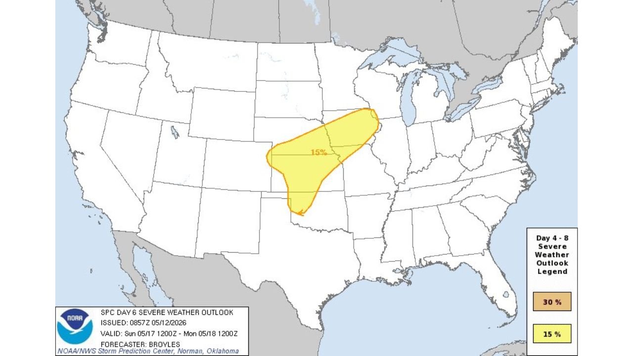
Kansas, Oklahoma, Nebraska and Upper Midwest Face 15 Percent Chance of Damaging Winds and Large Hail Saturday May 16 Through Monday May 18 as Threat Shifts North
KANSAS CITY, Kansas — Severe thunderstorms are possible across parts of the Plains and into the Upper Midwest on Saturday, May 16 and Sunday, May 17, 2026, with a 15 percent probability of severe weather outlined in both the Day 5 and Day 6 outlooks issued Tuesday, May 12.
Damaging winds and large hail remain the primary concerns across both days, with the threat zone shifting northward from Saturday into Sunday and continuing through Monday, May 18.
Saturday May 16 Severe Weather Outlook
The Day 5 outlook valid from Saturday, May 16 through Sunday, May 17 shows a 15 percent severe weather probability zone centered across the central Plains:
- A 15 percent probability of severe thunderstorms is outlined across a zone covering portions of the central Plains, with the risk area stretching from Kansas southward into northern Oklahoma and northern Texas.
- Damaging winds and large hail are the two primary threats with any severe storm that develops within this 15 percent zone on Saturday, May 16.
- The 15 percent threshold means that for any given point within the outlined area, there is a 15 percent chance of a severe thunderstorm occurring within 25 miles of that location during the valid period, which forecasters consider a meaningful and trackable threat worth monitoring closely.
Sunday May 17 Into Monday May 18 Threat Shifts North
The Day 6 outlook valid from Sunday, May 17 through Monday, May 18 shows the 15 percent severe weather zone shifting northward and expanding toward the Upper Midwest:
- The Sunday into Monday threat zone pushes the 15 percent severe weather probability northward and eastward compared to Saturday, covering a broader corridor from the central Plains into the Upper Midwest.
- The risk area on Sunday appears larger and tracks further north and east than the Saturday outlook, suggesting the storm system driving this threat is moving in that direction through the weekend.
- Damaging winds and large hail remain the primary concerns on Sunday, May 17 just as they are for Saturday, May 16, with no change in the dominant threat types as the system progresses.
What 15 Percent Means for Residents
A 15 percent severe weather probability is not a guarantee of storms but it is a threshold that warrants preparation and awareness for anyone living within the outlined zones:
- Historically, a 15 percent severe weather probability means isolated to scattered severe thunderstorms are expected to affect portions of the risk area, and at least some of those storms will produce damaging winds or large hail.
- This is not the highest risk level on the scale, but damaging winds strong enough to down trees and power lines and hail large enough to destroy vehicles and damage roofs are serious threats that can cause significant harm even in a lower-probability setup.
- Residents across Kansas, Oklahoma, Nebraska and the Upper Midwest within these outlined zones should have a weather alert plan ready before Saturday, May 16 and should monitor forecasts daily as confidence and storm details will increase significantly by Thursday and Friday.
Preparation Steps Before Saturday
Residents across Kansas, Oklahoma, Nebraska and the Upper Midwest have several days to get ready before this system arrives:
- Enable severe thunderstorm and tornado notifications on your weather app now so any warnings issued Saturday or Sunday reach you immediately.
- If you have outdoor events planned for Saturday, May 16 or Sunday, May 17 across the Plains or Upper Midwest, build in a severe weather contingency plan and identify the nearest sturdy shelter at your location.
- Check forecast updates daily through Friday, May 15 as the storm track, timing and intensity will become much clearer in the 24 to 48 hours before the threat arrives.
Cabarrusweekly.com will continue tracking this severe weather outlook across Kansas, Oklahoma, Nebraska and the Upper Midwest and will provide updates as the 15 percent damaging wind and large hail threat zones for Saturday, May 16 through Monday, May 18 develop and come into sharper focus.