Washington, Idaho, Colorado, Missouri, Oklahoma, Texas, New York, Ohio, Georgia and North Carolina Face Split Early June Pattern With Much Warmer Than Normal Temperatures in the West and Cooler Conditions From Boston and New York City to Cleveland and Atlanta
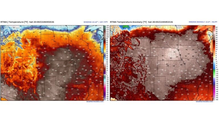
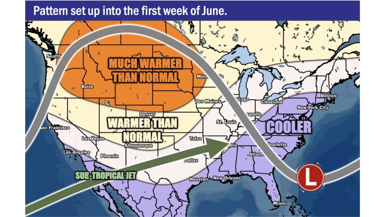
DENVER, Colorado — The weather pattern setting up into the first week of June 2026 will split the country sharply in two, with much warmer than normal temperatures dominating the West and central United States while cooler conditions settle across the East from Boston and New York City down through Cleveland and Atlanta.
The core of the warmth is expected to shift westward in early June, making the pattern a bit less active for the Midwest compared to the warmer and more active stretch forecast for late May.
Where It Will Be Much Warmer Than Normal
The early June pattern map shows two distinct warm zones across the West and central United States:
- A much warmer than normal zone is centered across the northern and central West, covering areas from Seattle and Boise eastward through Minneapolis and down toward Des Moines. This is the hottest zone on the map and represents temperatures significantly above what is typical for early June across these areas.
- A warmer than normal zone extends across a broader area from San Francisco, Los Angeles, Phoenix, Las Vegas and Albuquerque eastward through Denver, St. Louis and Tulsa into Dallas and Houston. This zone will see above average temperatures but not quite as extreme as the core warm area to the north.
Where It Will Be Cooler Than Normal
The eastern United States tells a very different story heading into early June 2026:
- Boston, Massachusetts and New York City, New York are squarely within the cooler than normal zone on the early June pattern map, meaning residents in the Northeast should expect below average temperatures as the first week of June arrives.
- Cleveland, Ohio and Indianapolis, Indiana fall within the cooler zone as well, a notable contrast to the much warmer than normal conditions forecast just to the west across the Midwest.
- Atlanta, Georgia and Charlotte, North Carolina are also included in the cooler than normal area, meaning the Southeast will not be sharing in the warmth building across the West and Plains during this period.
- Miami, Florida sits near a low pressure system shown on the map that will help drive the cooler and more unsettled pattern across the East into early June.
What the Sub-Tropical Jet Means for the South
A sub-tropical jet stream is shown on the pattern map tracking from the Pacific eastward across the South through Dallas, Houston and New Orleans. A jet stream is a fast-moving river of air high in the atmosphere that steers storms and weather systems:
- The sub-tropical jet tracking across the South will keep the Gulf Coast states including Houston, New Orleans and surrounding areas in an active weather zone as moisture is pulled northward from the tropics into the storm track.
- This setup can fuel rounds of heavy rainfall and thunderstorm activity across the South and Gulf Coast states during the early June timeframe as the jet stream pumps energy through the region.
What This Means for the Midwest
The shift of the warm core westward into early June means the Midwest will be in a transition zone rather than the heart of the heat and storm activity seen during late May:
- Des Moines, Iowa and Minneapolis, Minnesota sit on the eastern edge of the much warmer than normal zone, meaning temperatures will still run above average but the most intense heat will be focused further west.
- St. Louis, Missouri and Tulsa, Oklahoma fall within the warmer than normal zone, keeping above average temperatures in place but with less severe weather potential compared to the late May active period.
- The overall pattern shift westward means the Midwest transitions toward a slightly calmer but still warm early June compared to what the region will experience in the final weeks of May.
Cabarrusweekly.com will continue tracking the evolving early June temperature pattern across Washington, Idaho, Colorado, Missouri, Oklahoma, Texas, New York, Ohio, Georgia and North Carolina and will provide updates as the warm and cool zone boundaries develop through the first week of June 2026.