Ohio and Pennsylvania Mark One Year Since the April 2025 Derecho That Unleashed 65 to 120 MPH Winds Across 450 Miles
PENNSYLVANIA — One year ago today, on April 29, 2025, a powerful and destructive line of thunderstorms tore through Ohio and much of Pennsylvania, unleashing widespread wind gusts of 65 to 80+ mph and estimated winds of up to 120 mph in the hardest-hit areas. The event was officially classified as a derecho by the Storm Prediction Center in November 2025.
What Happened One Year Ago Today
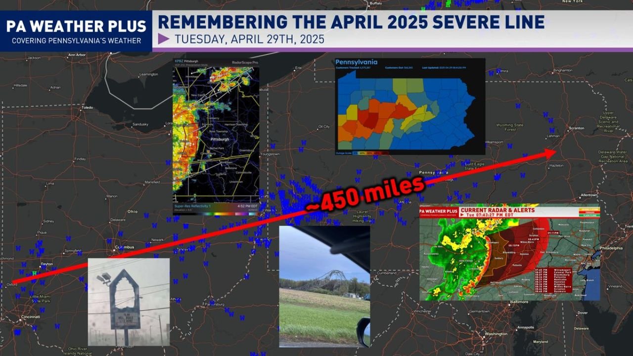
The storm system swept across a swath of approximately 450 miles, moving from Ohio through western and central Pennsylvania on the afternoon of April 29, 2025. Radar from Pittsburgh at 4:52 PM EDT showed the intense line pushing through communities including Pittsburgh, New Castle, Ellwood City, Youngstown, Grove City, Cranberry, Butler, Harrison Township, and Weirton.
The storm left widespread devastation in its wake. Communities lost power for several days to upwards of a week or longer. Widespread tree damage and property damage were reported throughout Pittsburgh and surrounding communities, with some of the worst structural damage concentrated in Cambria County, where wind gusts greater than 80 mph were observed and winds were estimated to reach as high as 120 mph, evidenced by destroyed antenna tower structures.
How This Storm Was Officially Classified as a Derecho
The SPC did not officially declare the event a derecho until November 7, 2025 — months after the storm occurred. The delay was due to ongoing updates to the definition of a derecho, aimed at separating regular bow echoes from more destructive and widespread wind events.
The National Weather Service Pittsburgh issued a Public Information Statement on November 7, 2025 at 7:42 AM EST, officially declaring the April 29 storm a derecho affecting eastern Ohio, northern West Virginia, and western Pennsylvania.
To meet the official derecho classification, an event must satisfy the following criteria:
- Wind damage swath extending at least 250 miles (about 400 kilometers)
- Wind gusts of at least 58 mph (93 km/h) along its length
- Several well-separated gusts of 75 mph (121 km/h) or greater
- Storm complex moving faster than the mean wind speed, making it primarily cold pool driven
The April 2025 event met and exceeded all of these thresholds.
What a Derecho Is and Why It Is So Destructive
A derecho is a widespread, severe windstorm originating from a mid-latitude thunderstorm complex known as a mesoscale convective system, driven by a cold pool and other internal forcing mechanisms. Unlike a tornado, a derecho produces destruction along a relatively straight path over a very long distance, which is why the damage from these events is sometimes described as straight-line wind damage.
The destructive potential of a derecho can rival that of a tornado across entire communities and counties simultaneously, rather than along a narrow track.
The Scale of the Power Outage Across Pennsylvania
Outage data from April 29, 2025 showed over 554,343 customers tracked as affected across Pennsylvania, with the heaviest outage concentration spread across the central and western portions of the state. Restoration took days to over a week for many communities due to the scale and intensity of the damage.
Today marks one year since one of the most significant wind events in recent Pennsylvania history — a storm that reshaped how forecasters and researchers define and classify destructive derecho events going forward.
Stay with CabarrusWeekly.com for continuing coverage of significant weather events and anniversaries across the region.