Early Season Tropical Threat Eyeing the Gulf Coast Between June 3 and June 10 as 171 Crude Oil Tankers Heading to Texas and Louisiana Ports Face Potential Disruption
GULF COAST — A potentially disruptive early season tropical weather system is showing signals in long-range forecast data targeting the Gulf of Mexico during the window of June 3 through June 10, 2026. With 171 crude oil tankers currently en route to U.S. Gulf Coast ports in Texas and Louisiana, a 55 percent surge above the typical monthly average of 110, even a slow-moving and non-hurricane system could carry significant consequences for Gulf Coast communities and energy infrastructure.
The Tanker Traffic Surge Makes This Threat More Significant
Under normal conditions, a modest tropical disturbance in the Gulf would draw limited attention. But the current situation is far from normal. As of mid-April 2026 data, approximately 171 crude oil tankers are heading to U.S. Gulf Coast ports in Texas and Louisiana, compared to a typical monthly figure of around 110 tankers. That is an increase of roughly 55 percent. These vessels are primarily empty inbound tankers arriving to load American crude oil for export. A slow-moving tropical system disrupting Gulf operations would be far more impactful than average given the extraordinary volume of maritime traffic currently converging on the region.
What the Long-Range Data Is Showing for June 3 to 10
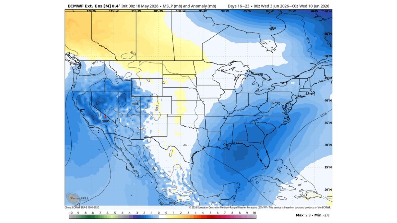
Long-range forecast data initialized on May 18, 2026 and valid for the period of June 3 through June 10, 2026 is showing a pressure anomaly signal in the Gulf region that is described as about as strong as you would expect to see from an ensemble blend this far out in advance. This does not automatically mean a major hurricane is coming. However, forecasters note that even a slow-moving and disruptive tropical system would be more impactful than average given current conditions in the Gulf.
This Does Not Have to Be a Hurricane to Be Dangerous
One of the most important points forecasters are making about this potential system is that it does not need to reach hurricane strength to cause serious problems. A slow-moving tropical disturbance or tropical storm sitting over or near the Gulf Coast during this window could bring:
- Heavy and prolonged rainfall across coastal Texas and Louisiana
- Storm surge along vulnerable Gulf Coast shorelines
- Disruption to port operations affecting tanker traffic and crude oil exports
- Flooding across low-lying coastal communities
Texas and Louisiana Residents Should Begin Monitoring This Closely
While June 3 through June 10 is still several weeks away, the early signal strength in the long-range data combined with the unusually high volume of Gulf tanker traffic makes this a situation worth watching closely. Residents along the Texas and Louisiana Gulf Coast should begin reviewing their hurricane and tropical storm preparedness plans now, well ahead of the potential arrival window.
Stay with CabarrusWeekly.com for continued monitoring and updates on this developing early season tropical weather threat through June.