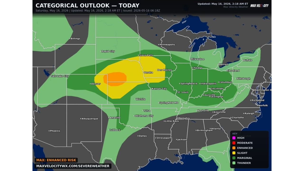
Nebraska, Iowa and Kansas Face an Enhanced Risk With 2 to 3 Inch Hail, Tornadoes and Damaging Winds Near Kearney, Omaha, Sioux Falls and Des Moines Saturday May 16 Today
KEARNEY, NEBRASKA — A busy day of severe weather is underway across the Central Plains, Midwest, and Ohio Valley on Saturday May 16, 2026, with the categorical outlook updated at 2:18 AM ET showing an Enhanced Risk centered just west of Kearney, Nebraska. The highest tornado threat is focused in this zone, with 2 to 3 inch hail also possible alongside damaging winds.
Threat Zone Breakdown for Today
Enhanced Risk core zone:
- Centered just west of Kearney extending through Omaha and into the Des Moines corridor
- Highest tornado threat of the entire day concentrated here
- 2 to 3 inch hail possible within this zone
Slight Risk surrounding zone:
- Covers Sioux Falls, Kansas City, Wichita, and Springfield MO
- Extends east toward Chicago, Indianapolis, Columbus, and Cincinnati
Marginal Risk outer zone:
- Reaches from Minneapolis and Milwaukee in the north
- Extends east all the way to Pittsburgh, Washington DC, Richmond, and Norfolk
- Extends south toward Oklahoma City, Dallas, and Memphis
Hazards Today
- Tornadoes — highest threat just west of Kearney Nebraska
- Very large hail up to 2 to 3 inches — possible in the Enhanced core
- Damaging winds — widespread across the Slight and Enhanced zones
A Wide Reaching Severe Weather Day
The marginal and thunder risk zones stretch from the Central Plains all the way to the East Coast today, making this one of the broadest severe weather footprints of the spring season. The core danger however remains tightly focused near Kearney and the Omaha corridor in Nebraska.
Stay with CabarrusWeekly.com for live updates as this Saturday severe weather event unfolds across the Central Plains and Midwest.