Mississippi and Alabama Brace for 2.64 Inches of Rain and Severe Storm Threat Stretching Into the Southeast This Week
MISSISSIPPI AND ALABAMA — A powerful cold front pushing through the South this week is building a multi-day heavy rain and severe weather event, with the peak danger window opening Wednesday, May 6 and continuing into Thursday, May 7, 2026, targeting areas from the lower Mississippi Valley through the Southeast and into the Southern Mid-Atlantic.
Rain Totals Piling Up Fast Before the Worst Even Arrives
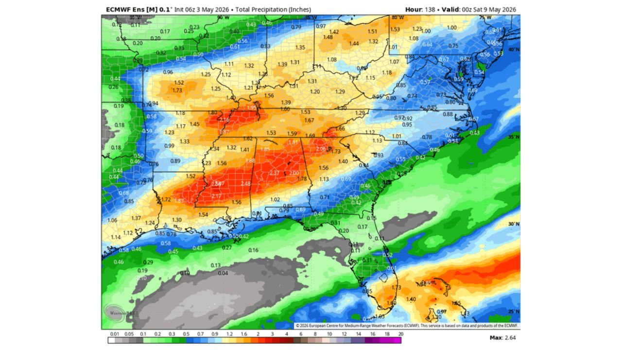
Total precipitation forecast through Saturday, May 9 shows the heaviest accumulations centered on Mississippi and Alabama, with isolated pockets reaching 2.27 to 2.64 inches across central Mississippi. The ensemble guidance max peaks at 2.64 inches. Farther east across the Carolinas and toward the Mid-Atlantic, totals drop into the 0.50 to 1.00 inch range.
Wednesday Evening Is When the Severe Weather Trigger Gets Pulled
The atmosphere becomes deeply unstable on Wednesday, May 6. K-Index values climb into the 35 to 43 range across central Mississippi and Alabama by 9:00 PM CDT, signaling a highly volatile environment capable of supporting organized and dangerous storms.
The Storm Prediction Center has placed portions of eastern Texas, Louisiana, Mississippi, and Alabama under a 15 to 29 percent probability of severe weather within 25 miles of a point, valid through 7:00 AM CDT Wednesday.
Thursday Pushes the Danger Northeast Toward the Carolinas
By Thursday, May 7 at 6:00 PM CDT, the K-Index corridor shifts into Georgia, South Carolina, and coastal North Carolina, with values in the 30 to 40 range extending from the Gulf Coast toward the Southern Mid-Atlantic. Confidence on timing and severity for Thursday remains lower as the system still needs to travel farther east.
Hazards Associated With This Multi-Day Event
- Heavy rainfall totaling 1.50 to 2.64 inches across Mississippi, Alabama, and surrounding states
- Severe thunderstorm probability of 15 to 29 percent on Wednesday across the highlighted zone
- Deep atmospheric instability with K-Index values reaching 40 to 43 across Mississippi and Alabama
Storm Timeline at a Glance
| Day | Valid Time | Area at Risk | Severe Probability |
|---|---|---|---|
| Wednesday, May 6 | Through 7 AM CDT | Eastern TX, LA, MS, AL | 15 to 29 percent |
| Wednesday evening | 9 PM CDT | MS and AL core | K-Index 35 to 43 |
| Thursday, May 7 | 6 PM CDT | Gulf Coast to Southern Mid-Atlantic | Elevated, lower confidence |
The Southeast Still Has Days Before the Full Impact Arrives
The energy driving this storm system has not yet made it fully into the Southeast. It will take until later in the work week before conditions deteriorate across the broader region. Heavy rain from this event will benefit some areas facing dry conditions, but the combination of high instability and surging moisture will make severe weather a serious concern from Wednesday onward.
Stay with CabarrusWeekly.com for updated forecasts as the timing for Wednesday night through the end of the week becomes clearer.