Kansas, Nebraska, Iowa and Missouri Face Worst Tornado Day of May With TORCON 7, Long-Track EF3 Plus Tornadoes, 2 Inch Hail and 75 mph Winds Monday May 18 Including Wichita, Omaha and Kansas City
WICHITA, Kansas – Today, Monday, May 18, is expected to be the worst tornado day of May so far, with a TORCON 7 tornado threat index in place and long-track EF3 or stronger tornadoes at risk across the corridor from Omaha, Nebraska to Wichita, Kansas. Following 22 tornadoes confirmed on Sunday, May 17, severe storms with tornadoes are possible from Michigan to Texas today, with very likely severe thunderstorms, 2 inch or larger hail and winds over 75 mph targeting the core risk zone.
What TORCON 7 Means for You Today
A TORCON 7 means there is a 70% chance of a tornado occurring within 50 miles of any point in the highest-risk zone today. This is one of the highest TORCON ratings issued and places Monday, May 18 among the most dangerous tornado days of the year. The specific area flagged for long-track EF3 or stronger tornadoes runs from near Omaha, Nebraska south to Wichita, Kansas. An EF3 tornado carries winds of 136 to 165 mph and can destroy well-built homes, overturn trains and throw vehicles hundreds of feet.
Three Simultaneous Life-Threatening Threats Today
Monday, May 18 is not a single-threat day. Three separate dangerous conditions are all in play simultaneously:
- Long-track EF3 or stronger tornadoes are the primary and most dangerous threat today across the Omaha to Wichita corridor, with severe storms capable of producing tornadoes stretching from Michigan to Texas.
- 2 inch or larger hail is possible across the core hail threat zone centered on Wichita, Kansas City, Omaha, Paradise and Parsons, Kansas, where a Very Likely damaging hail designation is in place today.
- Winds over 75 mph are possible across a Very Likely wind threat zone covering Omaha, Des Moines, Kansas City, Wichita, Parsons, Hays, Enid, Woodward and Oklahoma City.
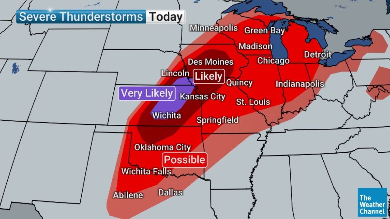
Severe Thunderstorm Probability Zones Today
The severe thunderstorm probability map for Monday, May 18 shows three distinct likelihood zones:
- Very Likely severe thunderstorms cover the core corridor including Lincoln, Kansas City and Wichita, where the greatest concentration of supercells and severe weather impacts are expected today.
- Likely severe thunderstorms extend across a wider area including Des Moines, Quincy, Springfield, St. Louis, Indianapolis, Chicago, Madison and Green Bay, where significant severe weather is expected but at a slightly lower confidence than the core zone.
- Possible severe thunderstorms reach Oklahoma City, Wichita Falls, Abilene, Dallas and surrounding areas across Texas and Oklahoma today.
Cities Facing the Greatest Danger Today
- Wichita, Kansas sits at the center of all three threat maps today facing long-track EF3 or stronger tornadoes, 2 inch or larger hail that is Very Likely and winds over 75 mph that are Very Likely on Monday, May 18.
- Kansas City, Missouri and Kansas fall within the Very Likely severe zone and face 2 inch hail, 75 mph winds and a tornado threat today.
- Omaha, Nebraska is within the long-track EF3 or stronger tornado risk corridor and also faces Very Likely winds over 75 mph today.
- Paradise and Parsons, Kansas sit inside the Very Likely hail zone with 2 inch or larger hail possible today.
- Des Moines, Iowa is within the Likely severe thunderstorm zone and faces the wind threat today.
- Woodward, Enid and Oklahoma City, Oklahoma fall within the Very Likely wind threat zone and the Possible hail zone for Monday, May 18.
- Wichita Falls and Abilene, Texas are within the hail and severe thunderstorm threat areas today.
- Minneapolis, Minnesota, Green Bay and Madison, Wisconsin, Chicago, Illinois and Detroit, Michigan fall within the broader Likely severe thunderstorm zone today.
22 Tornadoes Yesterday Sets the Stage for Today
Sunday, May 17 produced 22 confirmed tornadoes across the region, and forecasters are now saying Monday, May 18 is likely to surpass Sunday as the worst tornado day of May so far this year. The atmospheric setup is described as even more favorable for long-track, violent tornadoes today than it was yesterday. Anyone who lived through Sunday’s storms without incident should not assume Monday will be the same. The threat today is greater.
What You Must Do Right Now
Anyone from Wichita and Oklahoma City north through Omaha, Kansas City and Des Moines must be in their tornado shelter before storms fire this afternoon. Do not wait for a tornado warning. Move vehicles under solid cover immediately. Keep weather alerts active on your phone all day and all evening. Do not drive through any severe thunderstorm today. A 75 mph wind gust, 2 inch hailstone or EF3 tornado can disable or destroy a vehicle instantly.
WaldronNews.com will continue tracking this TORCON 7 long-track EF3 or stronger tornado outbreak across Kansas, Nebraska, Iowa and Missouri and will provide updates as tornado warnings, violent tornado reports and wind damage emerge throughout Monday, May 18.