El Nino Is Coming and the Southeast Including Florida Could Face a Rainy and Stormy Winter in December 2026 and January 2027
UNITED STATES — A potentially strong El Nino is developing, and long-range forecast data is already pointing toward significant implications for the Southeast United States heading into the winter of 2026 into 2027. Precipitation anomaly data for December 2026 and January 2027 shows an increased rain and storm signal for the Southeast, driven by a subtropical jet fueling Gulf energy into the region.
What the Long Range Data Shows for December 2026
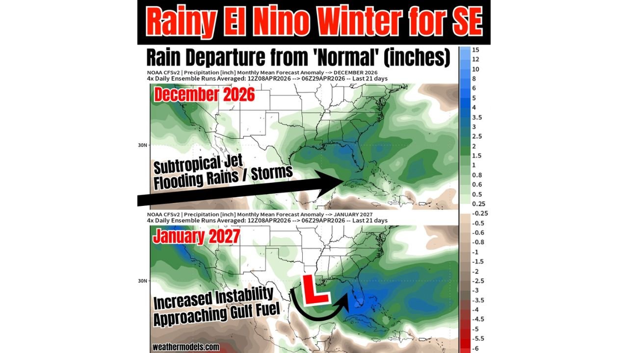
NOAA CFSv2 precipitation anomaly data averaged over the last 21 days of ensemble runs through April 29, 2026 shows a clear above normal rainfall signal across the Southeast, Florida, and the Gulf Coast for December 2026.
The primary driver is a subtropical jet stream pushing flooding rains and storms directly into the Southeast. The precipitation departure from normal shown on the map indicates above normal rainfall spreading across the Gulf states, Florida, and portions of the Southeast coast, with the greatest anomalies concentrated across Florida and the immediate Gulf Coast.
What January 2027 Could Bring
The January 2027 anomaly map shows a different but equally notable signal. A low pressure system positioned near the Gulf of Mexico is associated with increased instability and approaching Gulf fuel, pushing into the Southeast and Florida. The precipitation departure map for January shows a focused zone of significantly above normal rainfall centered over Florida, the Gulf Coast, and surrounding areas, with departure values reaching into the deepest blue shading on the scale.
This signal points toward increased flooding potential, more storms, and elevated rainfall for Florida and the Southeast during January 2027.
Why El Nino Makes This Pattern More Predictable
Historically, El Nino winters are associated with an active subtropical jet stream that channels Pacific and Gulf moisture directly into the Southeast United States. This fuels repeated rounds of heavy rainfall, flooding, and storm activity across Florida and the Gulf states during December and January. The long-range data currently aligns with this historically recognized pattern.
While Hurricane Season remains harder to forecast under a developing El Nino due to competing factors, the outlook becomes more defined heading into Fall and Winter, where the subtropical jet and Gulf energy combination creates a more predictable wet and stormy signal for the Southeast.
The Key Takeaway for the Southeast and Florida
More storms, more flooding rainfall, and an active winter pattern driven by the subtropical jet and Gulf moisture are what current long-range data suggests for Florida and the Southeast in December 2026 and January 2027. As El Nino continues to develop through the coming months, the confidence in this winter outlook will continue to increase.
Stay with CabarrusWeekly.com for continuing updates on the El Nino outlook and what it means for the Southeast heading into winter.