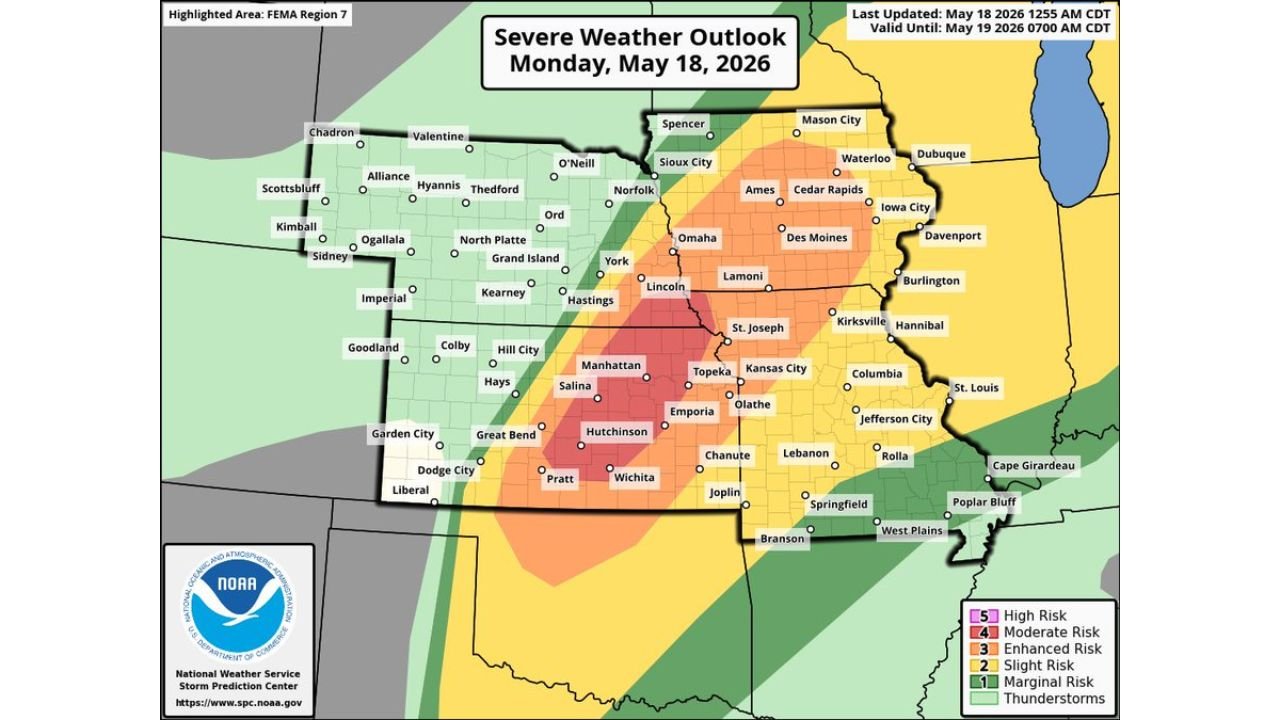
Kansas, Nebraska, Iowa and Missouri Face Level 4 Moderate Risk With Very Large Hail and Strong Tornadoes Monday May 18 Including Wichita, Hutchinson, Topeka, Salina and Omaha This Afternoon and Evening
WICHITA, Kansas – A Level 4 Moderate risk of severe weather is in place today, Monday, May 18, across Kansas, Nebraska, Iowa and Missouri, where multiple supercells capable of very large hail and strong tornadoes are expected to develop late this afternoon and evening. The outlook is valid through Tuesday, May 19 at 7:00 AM CDT, with Wichita, Hutchinson, Topeka, Salina and Omaha sitting inside the highest-risk corridor.
Risk Levels Across the Outbreak Zone Today
- Level 4 out of 5 Moderate Risk covers the core corridor centered on Wichita, Hutchinson, Salina, Manhattan, Topeka and Emporia, Kansas and stretches north through Lincoln, Omaha and Hastings, Nebraska. This is where multiple supercells with very large hail and strong tornadoes are expected this afternoon and evening.
- Level 3 out of 5 Enhanced Risk surrounds the Moderate zone covering Kansas City, St. Joseph, Olathe and Chanute, Missouri and Kansas, along with Grand Island, York, Kearney, Norfolk and Sioux City, Nebraska and Ames, Cedar Rapids, Des Moines and Iowa City, Iowa.
- Level 2 out of 5 Slight Risk extends the threat into Mason City, Waterloo, Dubuque and Davenport, Iowa, along with Columbia, Jefferson City, Springfield, Joplin, Rolla, Cape Girardeau and Poplar Bluff, Missouri and Lamoni, Burlington and Kirksville.
- Level 1 out of 5 Marginal Risk covers the outermost zone reaching North Platte, Goodland, Colby, Liberal, Dodge City, Garden City, Pratt and Great Bend, Kansas and Scottsbluff, Alliance, Chadron, Valentine and O’Neill, Nebraska.
Cities Inside the Level 4 Moderate Zone Today
- Wichita and Hutchinson, Kansas sit at the center of the Moderate risk and face the greatest threat of very large hail and strong tornadoes late this afternoon and evening, Monday, May 18.
- Salina, Manhattan, Topeka and Emporia, Kansas are squarely inside the Moderate corridor and should be fully sheltered and alert-ready before storms fire this afternoon.
- Omaha, Lincoln and Hastings, Nebraska fall within the Moderate risk zone and face very large hail and a real strong tornado threat this evening.
- Kansas City, St. Joseph and Olathe sit within the Enhanced risk zone bordering the Moderate corridor and face significant severe weather this afternoon and evening.
- Grand Island, York, Kearney and Norfolk, Nebraska are within the Enhanced zone and should prepare for all severe hazards through tonight.
Multiple Supercells Expected This Afternoon and Evening
Multiple supercell thunderstorms are expected to develop across the Moderate risk zone late this afternoon across Kansas and Nebraska. Supercells are rotating thunderstorms capable of producing very large hail that can total vehicles and destroy roofs, along with strong tornadoes that can cause significant structural damage across a wide swath of ground. The window of greatest danger runs from late afternoon through the evening hours Monday, May 18. Do not wait until a tornado warning is issued to seek shelter.
What You Must Do Right Now
Anyone across Wichita, Hutchinson, Topeka, Salina, Manhattan, Omaha, Lincoln and Kansas City must be weather-alert ready right now. Know your tornado shelter location. Move vehicles under cover before storms fire this afternoon. Keep weather alerts active on your phone through tonight. Do not be outdoors during peak storm hours this afternoon and evening. Very large hail and strong tornadoes can develop with very little warning.
WaldronNews.com will continue tracking this Level 4 Moderate severe weather outbreak across Kansas, Nebraska, Iowa and Missouri and will provide updates as supercell development, tornado warnings and hail reports emerge throughout Monday, May 18.