Maryland, Virginia, Pennsylvania and New England Face Record Challenging Mid 90s Heat Monday May 18 Spreading to New England by Tuesday With Major Heat Risk for Mid-Atlantic Cities
BALTIMORE, Maryland – High temperatures surging into the mid 90s are challenging temperature records across the east-central United States including the Mid-Atlantic this Monday afternoon, May 18, with the dangerous heat spreading into New England by Tuesday, May 19. A major level Heat Risk is forecast for major cities across the Mid-Atlantic through New England by Tuesday, May 19.
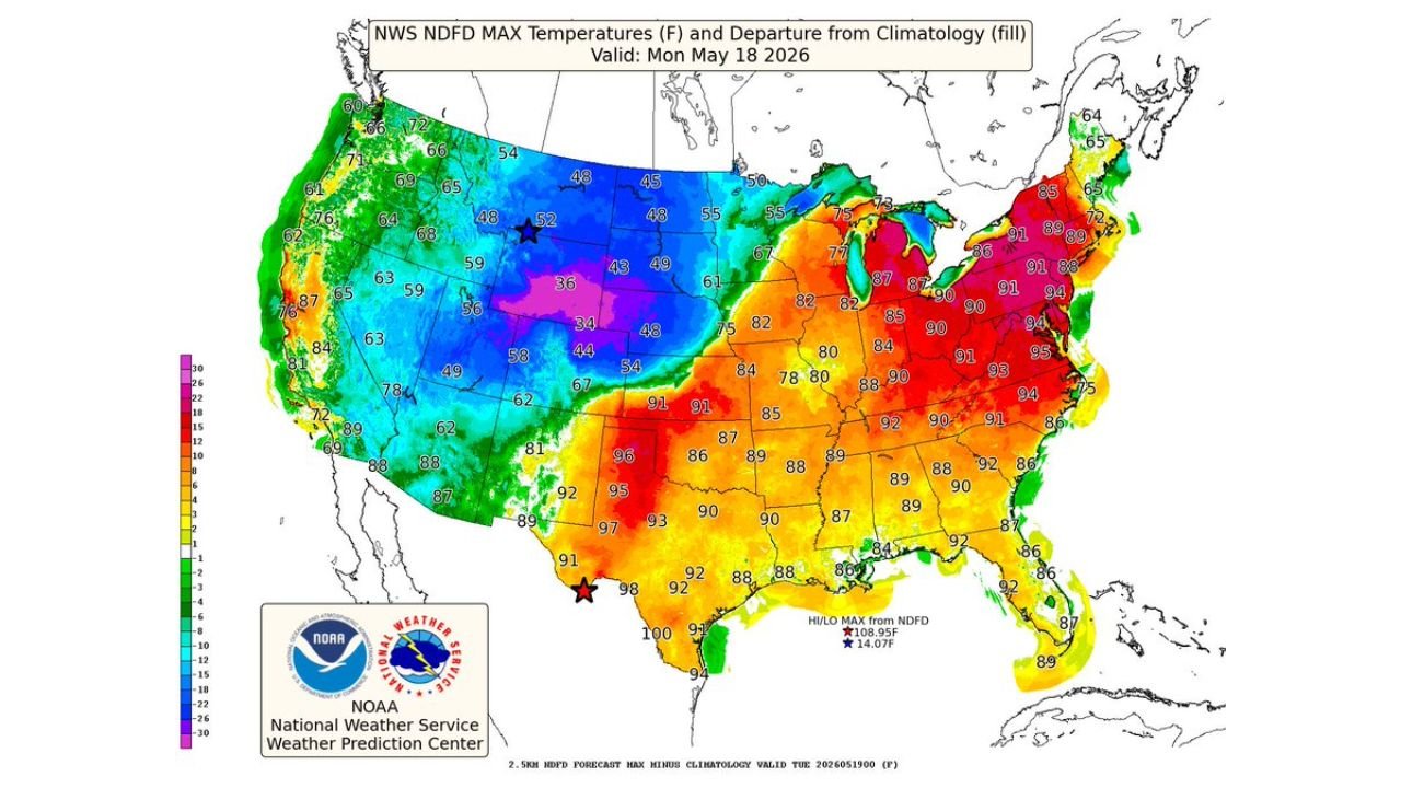
Temperature Map Monday May 18
Forecast high temperatures valid for Monday, May 18 show a dramatic contrast across the country, with dangerous heat dominating the eastern half:
- Temperatures across Maryland, Virginia, Pennsylvania and surrounding Mid-Atlantic states are running 91 to 95 degrees Monday afternoon, with departures well above normal for mid-May shown in deep red and orange on the map.
- The 94 to 95 degree readings visible across the Mid-Atlantic corridor on Monday, May 18 are challenging temperature records for this time of year across the region.
- Further south, Texas is seeing even more extreme readings with temperatures of 96 to 100 degrees Monday afternoon, with one location touching 108 degrees as the national maximum for Monday, May 18.
- Georgia, Alabama and the Southeast are running 86 to 92 degrees Monday as the heat dome extends across a broad swath of the eastern United States.
- In stark contrast, the northern Plains and Rockies are seeing temperatures of 34 to 52 degrees Monday, sitting 15 to 30 degrees below normal as cold air dominates the western half of the country.
What Major Heat Risk Means for Mid-Atlantic Cities
A major level Heat Risk is the second-highest category on the heat risk scale, indicating that dangerous heat is expected to cause significant impacts for people who are sensitive to extreme temperatures. By Tuesday, May 19, major Heat Risk conditions are forecast for major cities across the Mid-Atlantic through New England as temperatures in the mid 90s combine with humidity to push heat index values even higher. Elderly residents, young children, outdoor workers and anyone without air conditioning are at serious risk during major Heat Risk conditions.
Cities Facing the Worst Heat Monday and Tuesday
- Baltimore, Maryland is running 91 to 95 degrees Monday afternoon and faces major Heat Risk conditions as the heat continues into Tuesday, May 19.
- Philadelphia, Pennsylvania and surrounding areas are within the 90 to 94 degree range Monday with dangerous heat continuing through Tuesday.
- New York and surrounding Mid-Atlantic communities face the heat spreading north through Monday and intensifying through Tuesday, May 19.
- New England cities are in the path of this heat event spreading north by Tuesday, bringing the major Heat Risk designation to a wide area of the northeastern United States.
What You Should Do Right Now
Anyone across Maryland, Virginia, Pennsylvania and New England should limit outdoor exposure during peak heating hours of noon to 6:00 PM through Tuesday, May 19. Check on elderly neighbors and family members who may not have air conditioning. Drink water consistently throughout the day even if you do not feel thirsty. Never leave children or pets in parked vehicles under any circumstances during major Heat Risk conditions.
WaldronNews.com will continue tracking this mid 90s record-challenging heat and major Heat Risk threat across Maryland, Pennsylvania, Virginia and New England and will provide updates as temperature records and heat impacts develop through Tuesday, May 19.