This Afternoon, Abilene, Big Spring, Midland, and Snyder Face 95% Watch Probability as SPC Issues Mesoscale Discussion With 80 MPH Winds, 2.50-Inch Hail, and Tornado Threat Valid Until 2:30 PM CDT
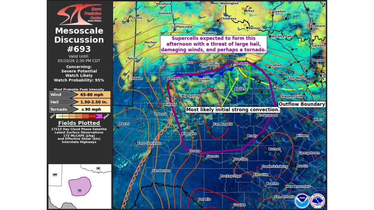
WEST TEXAS — The Storm Prediction Center has issued Mesoscale Discussion #693 valid until 2:30 PM CDT on May 10, 2026, flagging a 95% severe weather watch probability across west and central Texas. Supercells are expected to form this afternoon bringing large hail, damaging winds, and a possible tornado.
What SPC Mesoscale Discussion #693 Shows
The discussion is centered on a zone of most likely initial strong convection near Abilene, Snyder, Big Spring, and the Midland-Odessa area, with an outflow boundary identified near Abilene acting as a focal point for storm development.
Peak intensity values from the discussion:
| Hazard | Most Probable Peak Intensity |
|---|---|
| Wind | 65 to 80 mph |
| Hail | 1.50 to 2.50 inches |
| Tornado | Up to 90 mph |
Severe Watch Almost Certain
With a watch probability of 95%, a severe thunderstorm or tornado watch issuance is nearly guaranteed for the affected area. The discussion is valid through 2:30 PM CDT, meaning watch issuance is expected imminently.
Cities within or near the threat corridor include Abilene, Snyder, Big Spring, Midland, Odessa, Lamesa, Haskell, and San Angelo.
Act Before Storms Arrive
Supercells are expected to fire this afternoon. If you are anywhere in the west or central Texas region, have your shelter plan ready and monitor for watch and warning issuance closely.
Stay with CabarrusWeekly.com for live updates as this severe weather threat rapidly develops across west Texas this afternoon.