Maryland Eyes 2 Inches of Rainfall Relief Through May 5 as Heavy Snow Piles Up Across the Northern US
MARYLAND — An active weather pattern building into the start of May is bringing welcome rainfall relief to Maryland after a prolonged dry stretch, with total precipitation forecasts through May 5, 2026 showing 2.00 to 2.84 inches accumulating across the state — while simultaneously, heavy and historic snowfall continues piling up across the Northern United States as the same active pattern delivers dramatically different outcomes by region.
Maryland Picks Up 2 to Nearly 3 Inches of Rain Through May 5
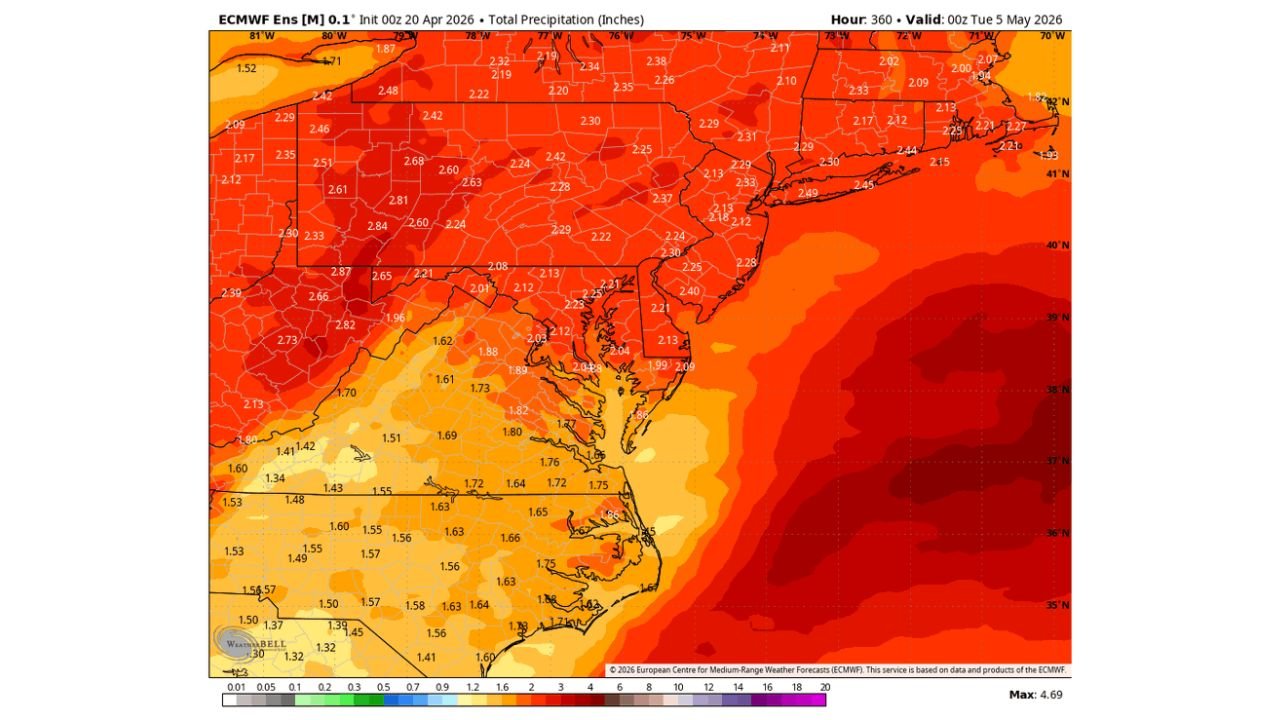
Total precipitation forecast data valid through May 5 shows Maryland sitting in a solid rainfall zone, with accumulations ranging from 2.01 to 2.84 inches across western and central Maryland and 1.99 to 2.40 inches across the Eastern Shore and coastal counties. Northern Maryland and the Pennsylvania border counties see some of the highest totals in the region, with values approaching 2.60 to 2.84 inches in spots.
This rainfall represents a meaningful catchup opportunity for a state that has seen well-below-normal precipitation through much of the spring season, with the active pattern finally delivering the moisture Maryland needs heading into May.
| Region | Projected Rainfall Through May 5 |
|---|---|
| Western and Central Maryland | 2.01 to 2.84 inches |
| Northern Maryland border counties | 2.60 to 2.84 inches |
| Eastern Shore and coastal MD | 1.99 to 2.40 inches |
| Southern Maryland | 1.82 to 2.04 inches |
Heavy Snow Buries the Northern US Through May 5
While Maryland receives rain, the same active pattern is delivering heavy and widespread snowfall across the Northern United States through May 5. Total snow accumulation data shows deep pink and magenta values — indicating 30 to 48 inches or more — blanketing the Northern Plains, Upper Midwest, and portions of Canada, with significant accumulations also extending into the Pacific Northwest, Northern Rockies, and Great Lakes region.
The sharp contrast between heavy late-season snow in the North and beneficial rainfall in the Mid-Atlantic reflects the strongly active and amplified pattern expected to dominate through the first week of May.
No Big Warmups — Temperatures Stay Near Normal for 2 Weeks
Despite the active storm pattern, Maryland should not expect extended periods of warmth over the next two weeks. The ongoing storm track will keep temperatures averaging fairly close to normal through mid-May, with any brief warmups quickly cut short by the next storm system moving through the region.
Stay with CabarrusWeekly.com for continuing rainfall and temperature forecast updates across Maryland through the start of May.