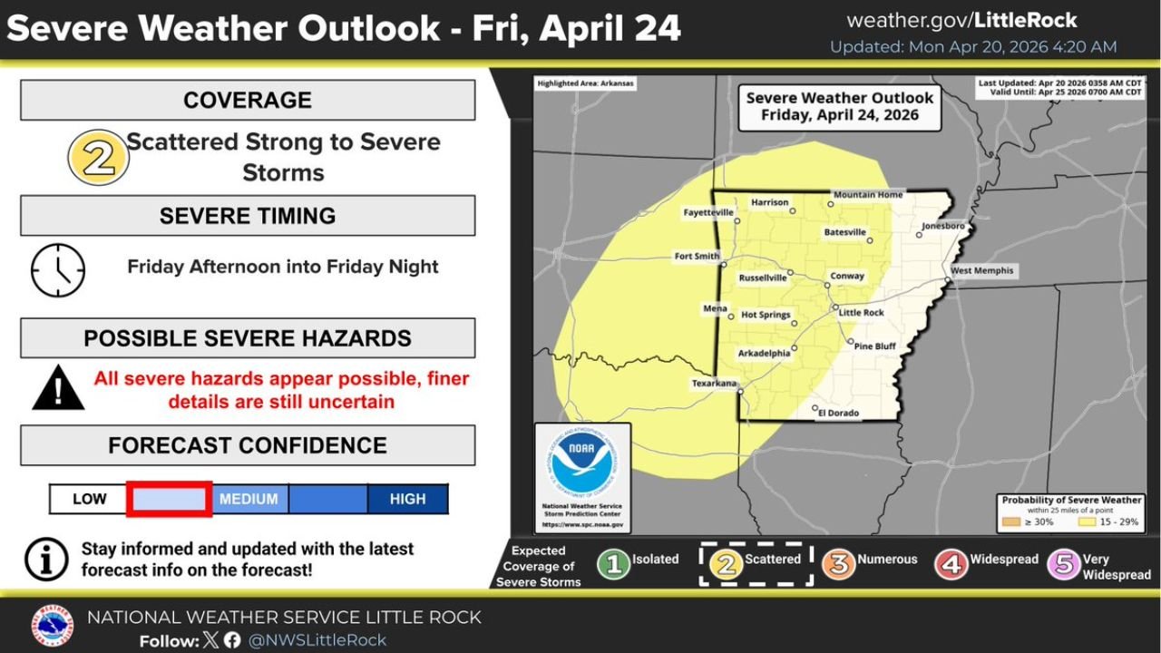
All Severe Hazards Possible as Scattered Strong to Severe Storms Target Arkansas Friday Afternoon Into Friday Night
ARKANSAS — The National Weather Service Little Rock has issued a formal severe weather outlook for Friday April 24, 2026, with scattered strong to severe thunderstorms expected to develop across a large portion of the state from Friday afternoon into Friday night — and confidence in this event continuing to increase as the week progresses.
Scattered Coverage With All Hazards on the Table
Friday’s outlook carries a Coverage Level 2 — Scattered Strong to Severe Storms designation across Arkansas, indicating multiple rounds of storm activity are expected but not yet reaching the numerous or widespread threshold. Critically, the NWS Little Rock explicitly states that all severe hazards appear possible with Friday’s storm system — meaning tornadoes, damaging winds, and large hail each carry a real threat potential across the affected area.
Forecast confidence is currently sitting at low to medium, reflecting the fact that finer details on storm timing, intensity, and exact placement remain uncertain at this range. All of Arkansas should continue monitoring updated forecasts through the week.
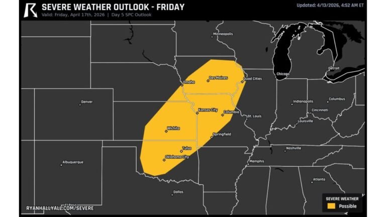
Western and Central Arkansas Most Exposed in Current Outlook
The severe weather probability map for Friday shows a 15 to 29 percent severe weather probability zone covering most of western and central Arkansas, with cities including Fayetteville, Fort Smith, Russellville, Conway, Mena, Hot Springs, Little Rock, Arkadelphia, and Texarkana all falling within the current risk footprint. A 30 percent or higher zone is depicted across the far western portion of the state near the Oklahoma border.
| Element | Details |
|---|---|
| Storm Coverage | Scattered — Level 2 |
| Timing | Friday afternoon into Friday night |
| Hazards | All severe hazards possible |
| Confidence | Low to medium — details still uncertain |
| Highest Risk Zone | Western and central Arkansas |
Risk Area Has Shifted West but All of Arkansas Remains at Risk
The latest SPC risk area has shifted slightly westward compared to earlier forecasts, but NWS Little Rock is explicitly warning that all areas of Arkansas should continue monitoring the forecast throughout the week. The westward shift does not remove eastern Arkansas from consideration, and the outlook is expected to be refined with additional updates before Friday arrives.
Residents across the entire state — from Fayetteville and Fort Smith in the west to Jonesboro and West Memphis in the east — should have severe weather plans in place before Friday afternoon.
Stay with CabarrusWeekly.com for live severe weather updates and outlook refinements across Arkansas through Friday.