3 to 5 Inches of Excessive Rain Drowns Chicago and the Upper Midwest in 7 Days While Southern Indiana and Kentucky Stay Bone Dry
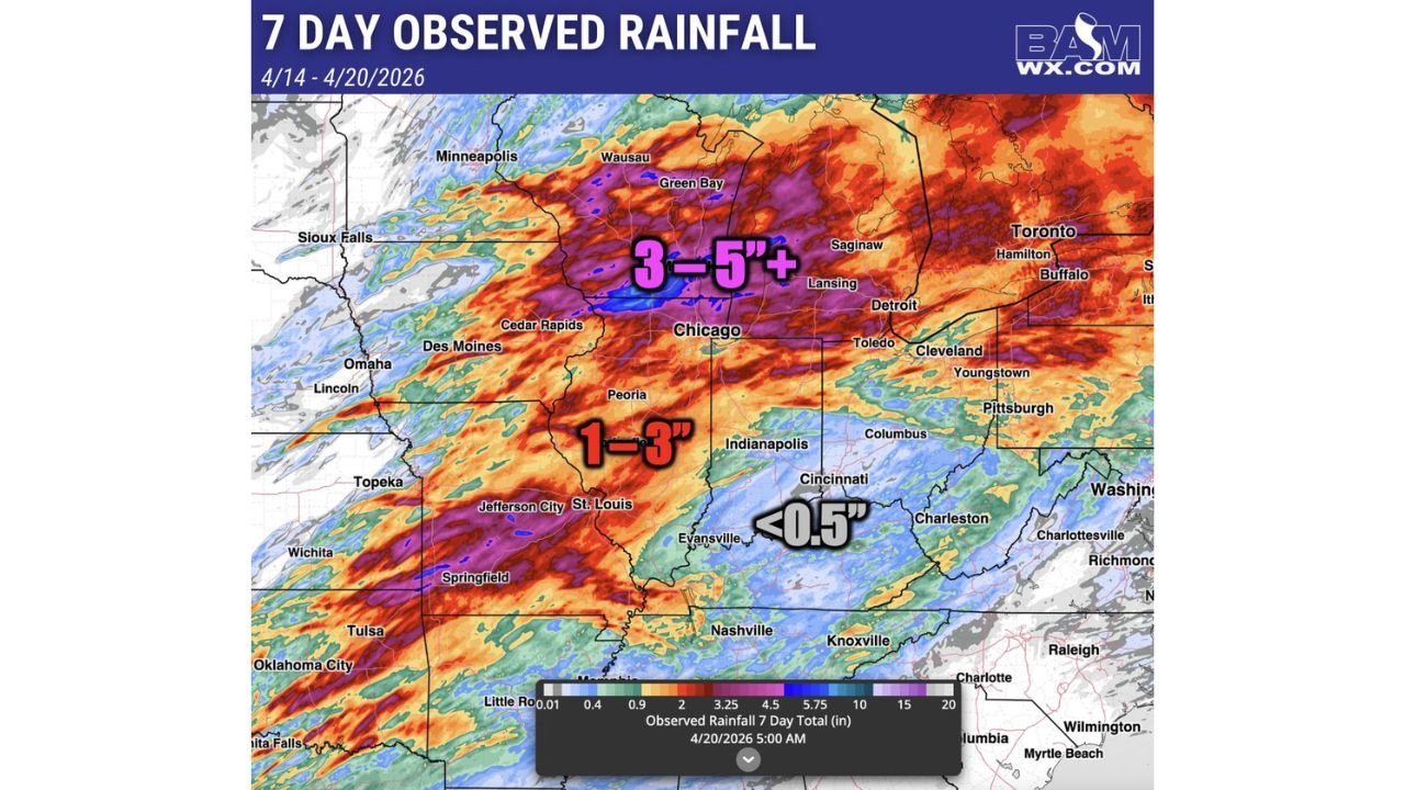
UPPER MIDWEST, UNITED STATES — A week of relentless rainfall from April 14 through April 20, 2026 has dumped 3 to 5 inches or more across the Upper Midwest — battering Chicago, Green Bay, Wausau, Lansing, and Detroit — while the southern half of Indiana, Ohio, and Kentucky were almost entirely skipped over, recording less than 0.5 inches during the same period.
Chicago and Upper Midwest Core Take the Hardest Hit
Seven-day observed rainfall data shows the bull’s-eye of the heaviest precipitation centered across a corridor from Minneapolis and Sioux Falls eastward through Green Bay, Chicago, Wausau, Lansing, and Saginaw, with totals reaching 3 to 5 inches or greater across this entire zone. Locally higher amounts are possible within the heaviest training rainfall bands across Wisconsin and northern Illinois.
The excessive rainfall footprint extends southward through Cedar Rapids, Des Moines, Peoria, and St. Louis, where 1 to 3 inches accumulated over the same 7-day period — still well above normal for a single week but significantly less than the core zone to the north.
Southern Indiana, Ohio and Kentucky Left Almost Completely Dry
In a striking contrast, the southern half of Indiana, most of Ohio, and Kentucky recorded less than 0.5 inches over the entire 7-day period. Cities including Indianapolis, Cincinnati, Columbus, Evansville, Louisville, and Nashville sit within this dry pocket, highlighting the sharply defined precipitation gradient that set up across the region during this stretch.
| Zone | 7-Day Rainfall Total | Key Cities |
|---|---|---|
| Upper Midwest core | 3 to 5 inches or more | Chicago, Green Bay, Lansing, Saginaw |
| Central Midwest | 1 to 3 inches | Des Moines, Peoria, St. Louis |
| Southern IN, OH, KY | Less than 0.5 inches | Indianapolis, Cincinnati, Evansville |
Welcome Break Coming for the Soaked Upper Midwest
After seven consecutive days of excessive rainfall, a much-needed break is arriving for the areas that have been hit hardest across the Upper Midwest. Drier conditions over the next several days will give saturated soils, swollen rivers, and flood-stressed communities a chance to begin recovering before the next storm system approaches.
For the southern half of Indiana, Ohio, and Kentucky, the incoming pattern may finally deliver some of the moisture these areas missed during the past week’s active storm stretch.
Stay with CabarrusWeekly.com for continuing rainfall and flood recovery updates across the Upper Midwest and Ohio Valley.