Widespread Severe Storms With Tornadoes and Large Hail to Erupt Across the Midwest and Plains Late Thursday Into Friday
MIDWEST, UNITED STATES — A powerful and deepening storm system is set to unleash widespread severe thunderstorms across the Midwest and Central Plains late Thursday April 23, with damaging winds, large hail, and a few tornadoes all on the table before the system pushes east and triggers another round of severe weather across the lower Mississippi Valley on Friday April 24.
Deep Low Pressure Drives Severe Threat Late Thursday
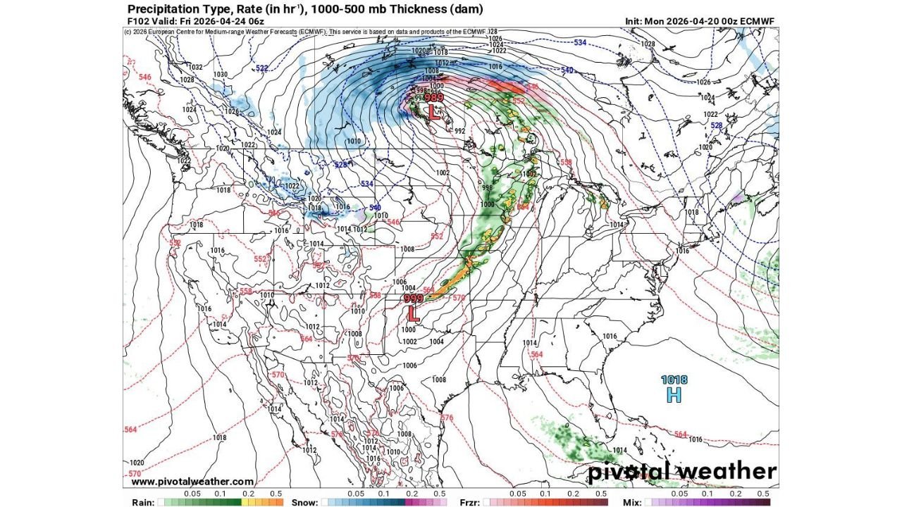
Surface analysis valid Friday April 24 06Z shows a deep and intensifying low pressure system — with central pressure readings near 989 to 992 millibars — positioned across the central Plains and tracking rapidly northeastward. This aggressively deepening surface low is the primary driver of Thursday’s severe weather outbreak, generating the strong wind shear, moisture convergence, and atmospheric instability needed to support widespread organized severe thunderstorm development.
A sharp cold front trailing southward from the low center cuts across the central Plains, with a second low pressure area near 999 millibars positioned further south — extending the severe weather threat corridor across a long north-to-south swath of the region.
Damaging Winds, Large Hail and Tornadoes All Possible Thursday
The Thursday severe weather threat encompasses all three major hazard types. Damaging straight-line winds are the most widespread concern as squall lines organize along and ahead of the cold front. Large hail is possible particularly with any discrete supercell activity that develops ahead of the main line. A few tornadoes cannot be ruled out, especially during the evening hours as the atmosphere becomes most unstable across the Midwest and Central Plains.
| Hazard | Threat Level |
|---|---|
| Damaging Winds | Widespread — primary threat |
| Large Hail | Possible with discrete supercells |
| Tornadoes | A few possible late Thursday |
| Coverage | Widespread across Midwest and Central Plains |
Friday Severe Weather Shifts to the Lower Mississippi Valley
As the storm system continues tracking east overnight Thursday into Friday, the severe weather focus shifts southeastward into the lower Mississippi Valley for Friday April 24. The cold front and associated precipitation shield — clearly shown pushing into the central and southern Plains on the valid-time map — will drive another organized round of severe thunderstorm potential across Arkansas, Missouri, Tennessee, and surrounding areas during Friday’s daylight and evening hours.
Snow and Wintry Precipitation on the Northwest Flank
On the cold northwest side of the deepening low, heavy snow and wintry precipitation is simultaneously occurring across portions of the Northern Plains and Upper Midwest, with the blue and white precipitation signatures on the forecast map extending from the Dakotas northward into Canada. This cold-side wintry activity underscores just how powerful and broad this storm system is becoming as it crosses the central United States.
Stay with CabarrusWeekly.com for live severe weather and storm system updates across the Midwest, Plains, and lower Mississippi Valley through Friday.