Very Large Hail and Tornadoes to Target East and Northeast Arkansas Monday April 27 With First Tornado Window Opening Sunday PM Across Western Arkansas
ARKANSAS — Atmospheric parameter data valid Tuesday April 28 is producing a strong and well-defined signal for east and northeast Arkansas on Monday April 27, with forecasters identifying a setup capable of delivering very large hail and a meaningful tornado threat — while the most favorable tornado window may actually arrive Sunday afternoon as storms enter western and northwest Arkansas during the best overlap of wind shear and instability.
East and Northeast Arkansas Carry the Highest Monday Threat
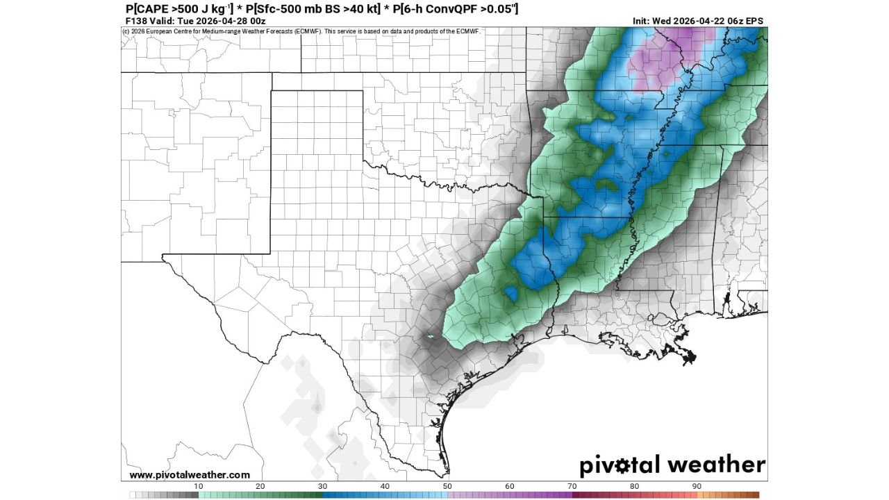
Combined severe weather parameter probability data — incorporating CAPE exceeding 500 J/kg, bulk wind shear above 40 knots from the surface to 500mb, and convective rainfall — shows the highest probability values concentrated across east and northeast Arkansas, with values reaching into the blue and purple shading zones of 60 to 80 percent and above. This concentration of favorable severe weather ingredients in eastern Arkansas pinpoints the region as the primary bull’s-eye for Monday’s most significant storm activity.
The probability signal extends northward into western Tennessee and the Memphis corridor, consistent with other data sources that have been flagging the Mississippi Valley as the core concern for Monday’s event.
Very Large Hail and Tornado Risk Both on the Table
For Monday’s event across Arkansas, forecasters are explicitly identifying very large hail potential as the primary concern alongside a real and meaningful tornado risk. The combination of deep instability and strong wind shear creates an environment favorable for supercell thunderstorms — the storm mode most capable of producing both very large hail and organized tornado development simultaneously.
| Threat | Level | Primary Zone |
|---|---|---|
| Very large hail | Primary concern | East and NE Arkansas |
| Tornado risk | Meaningful | East and NE Arkansas, Memphis corridor |
| Parameter probability | 60 to 80%+ | East Arkansas, W Tennessee |
Sunday PM Into Western Arkansas — Best Tornado Window
In a critical timing detail, forecasters note that the most favorable window for tornado development may actually occur Sunday afternoon — before Monday’s main event — as storms enter western and northwest Arkansas during the period of best overlap between wind shear and atmospheric instability. Residents across western Arkansas should not wait for Monday to be on alert, as the tornado threat may arrive as early as Sunday afternoon and evening as the storm system pushes into the state from the west.
Strong Signal at 5 Days Out — Details Will Sharpen
The strength and definition of this parameter signal at 5 days out is notable and reflects growing forecast confidence in a significant severe weather event for Arkansas spanning Sunday afternoon through Monday. Specific storm timing, tornado tracks, and hail sizes will become clearer as the week progresses and updated data refines the solution.
Stay with CabarrusWeekly.com for daily severe weather updates across Arkansas, Tennessee, and the Mississippi Valley through Monday April 27.