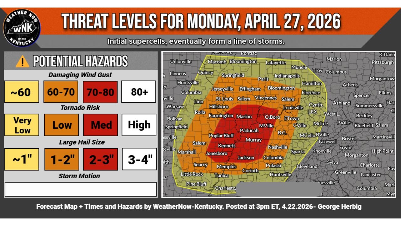
Kentucky and Western Tennessee Face 70 to 80 MPH Winds 2 to 3 Inch Hail and Medium Tornado Risk Monday April 27
KENTUCKY — A very serious severe weather threat is five days away from striking portions of Kentucky and the surrounding region, with threat level mapping for Monday April 27, 2026 showing a concentrated bull’s-eye of 70 to 80 MPH damaging winds, 2 to 3 inch large hail, and a medium tornado risk centered across western Kentucky, the Paducah corridor, and into western Tennessee — as initial supercells are expected to eventually organize into a destructive line of storms.
Core Threat Zone — Paducah, Murray, Kennett and Jonesboro
The most dangerous zone on Monday’s threat level map is depicted in deep red, centered across a corridor covering Paducah, Murray, Kennett, Jonesboro, and the surrounding western Kentucky and southeast Missouri region. This core zone carries the highest hazard levels across all three threat categories simultaneously — making it the area of greatest concern for Monday’s event.
An orange surrounding zone extends the elevated threat outward across a broader area including St. Louis, Salem, Vincennes, Farmington, Marion, Jackson, Memphis, and Corinth, while a yellow outer zone covers much of the broader region from Little Rock and Searcy northward through Springfield and Indianapolis.
70 to 80 MPH Wind Gusts in the Core Zone
Damaging wind gusts are one of the headline hazards for Monday’s event. The core red zone carries 70 to 80 MPH wind gust potential, while the surrounding orange zone faces 60 to 70 MPH gusts. Even the outer yellow zone cannot rule out winds near 60 MPH as the storm system pushes through. Wind gusts of this magnitude are capable of downing trees, destroying structures, and causing widespread power outages across the affected corridor.
Medium Tornado Risk — Supercells Before the Line Forms
Monday’s tornado risk reaches the medium level across the core red zone — a significant designation that reflects the expected storm mode evolution. Forecasters anticipate initial supercell development before storms eventually consolidate into a squall line. The supercell phase of the event carries the highest tornado potential, particularly across the Paducah and western Kentucky corridor during the early stages of storm development.
The surrounding orange zone carries a low tornado risk, while the outer yellow zone sits at very low but not zero tornado potential.
2 to 3 Inch Hail Possible in the Core — Up to 4 Inches Not Ruled Out
Large hail is the third major hazard for Monday. The core red zone faces 2 to 3 inch diameter hail, capable of shattering vehicle windows, damaging roofs, and destroying crops. The surrounding zone carries 1 to 2 inch hail potential. In isolated supercell scenarios ahead of the main line, hail approaching 3 to 4 inches cannot be completely ruled out.
| Hazard | Core Red Zone | Orange Zone | Yellow Zone |
|---|---|---|---|
| Wind Gusts | 70 to 80 MPH | 60 to 70 MPH | Near 60 MPH |
| Tornado Risk | Medium | Low | Very Low |
| Hail Size | 2 to 3 inches | 1 to 2 inches | Up to 1 inch |
Storm Mode — Supercells First, Then a Line
The expected storm mode evolution on Monday begins with discrete supercell development during the afternoon and early evening — the phase carrying the greatest tornado and large hail potential. As the event matures, storms are expected to consolidate into a squall line, shifting the dominant hazard toward widespread damaging winds across a broader swath of the region.
Residents across western Kentucky, the Paducah area, Murray, western Tennessee, and southeast Missouri should treat Monday as a serious and life-threatening severe weather day and have shelter plans finalized well before the event arrives.
Stay with CabarrusWeekly.com for daily threat level updates across Kentucky, Tennessee, and the surrounding region through Monday April 27.