The Dryline Is Active Across the Central U.S. and It Is One of the Most Dangerous Storm Triggers on Earth
UNITED STATES — A weather boundary that most people have never heard of is quietly one of the most powerful storm triggers on the planet — and right now, it is running straight through the heart of America.
The Invisible Line That Splits the Country in Half
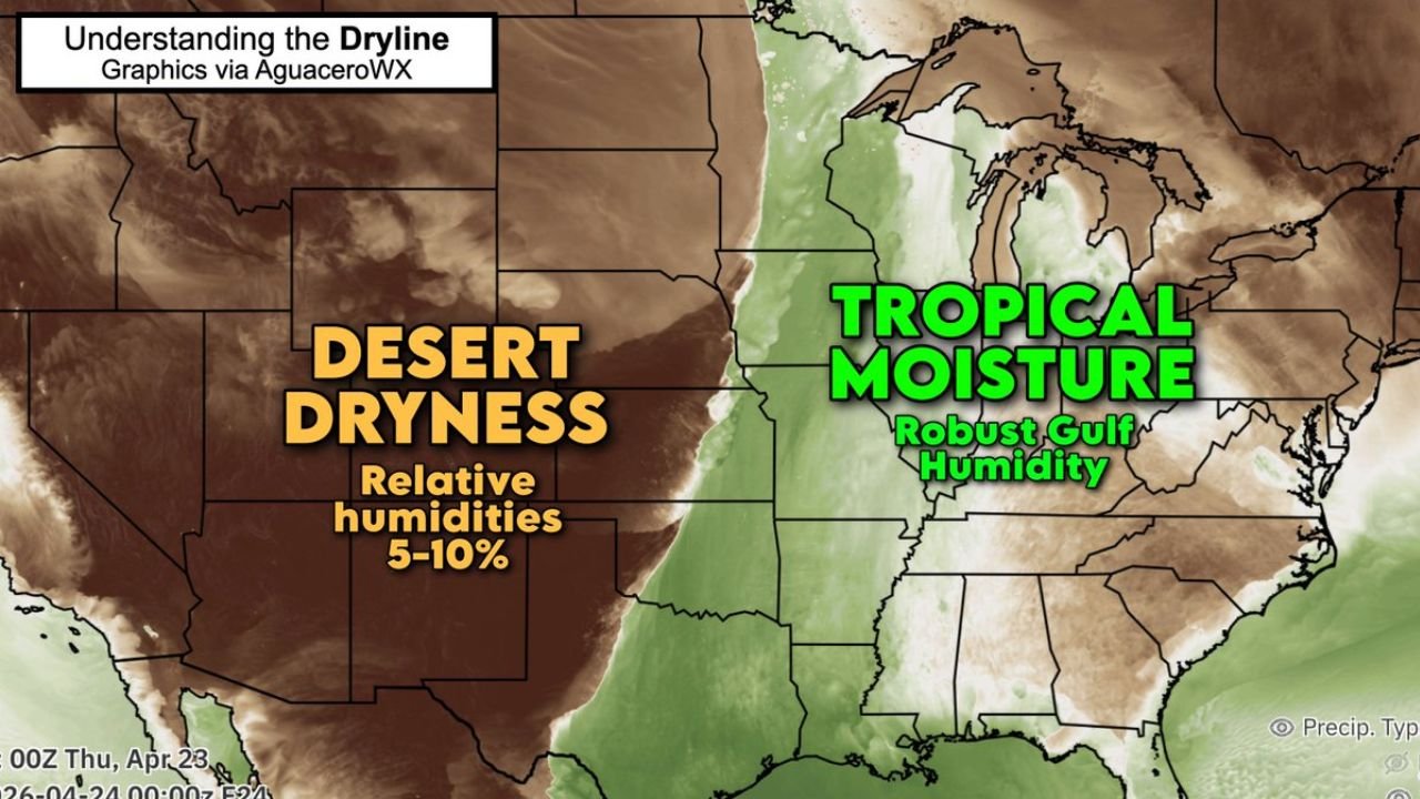
It has no clouds, no rain, and no dropping temperatures — but the dryline is responsible for some of the most violent weather the United States produces every year. Running roughly through the Central Plains, this boundary marks the meeting point between two radically different airmasses: desert dryness pushing in from the west and tropical Gulf moisture surging in from the east.
The contrast is almost impossible to believe until you have seen it firsthand. In parts of Oklahoma, a drive of just 5 miles can separate a Sahara-like airmass from rainforest-like humidity. Dew points can swing by 50 degrees in barely 8 miles.
Desert Air vs. Gulf Air — A Clash of Extremes
On the western side of the dryline, relative humidity values are running between just 5 and 10 percent — bone-dry desert air originating from the interior Southwest. On the eastern side, robust Gulf moisture pushes northward, carrying the kind of oppressive, tropical humidity more commonly associated with Florida or the Caribbean.
No place on Earth routinely sees this kind of extreme atmospheric contrast compressed into such a narrow zone. That is what makes North America’s dryline uniquely dangerous.
How the Dryline Actually Triggers Storms
The science behind it is counterintuitive. Dry air is actually denser than moist air — not lighter. This is because air is primarily nitrogen gas, which weighs more per molecule than water vapor. The more moisture the air holds, the lighter it becomes compared to dry air.
This density difference is what makes the dryline so explosive. The heavier dry air effectively acts as a wedge, pushing underneath and lifting pockets of warm, moisture-laden air to its east. Once that moist air gets forced upward, it rapidly cools, condenses, and — given enough atmospheric instability — erupts into severe thunderstorms.
What These Storms Produce
The dryline is directly linked to some of the nation’s most dramatic severe weather. When conditions align during April and May, rounds of violent storms fire along the boundary with near-clockwork regularity. Those storms routinely produce:
- Tornadoes, including significant long-track events
- Baseball-sized hail
- Torrential rainfall and flash flooding
- Damaging straight-line winds
One critical detail that catches many people off guard: unlike a cold front, the dryline does not cool things down behind it. Temperatures on the dry western side often stay warm — or even climb hotter — after storms move through.
Why This Matters Right Now
As of April 23, the dryline is clearly established across the Central U.S., with the sharp boundary between desert dryness and tropical Gulf moisture in place. This setup is precisely the kind of pattern that fuels late-season severe weather outbreaks across the Plains and into portions of the Mississippi Valley.
Residents from the Southern and Central Plains eastward through the Mid-South should monitor forecasts closely during active dryline setups throughout the spring season.
Stay with CabarrusWeekly.com for continuing coverage of severe weather patterns and what they mean for communities across the region.