Kansas and Oklahoma Face Significant Severe Weather Threat With Strong Tornadoes and Very Large Hail Possible Today
SOUTHERN PLAINS — A significant severe weather outbreak is underway across the southern Plains today, April 23, 2026, with robust supercell thunderstorms expected to produce strong tornadoes, very large hail, and all associated hazards from southern Kansas through Oklahoma.
Supercells Targeting a Dangerous Triple Point Setup
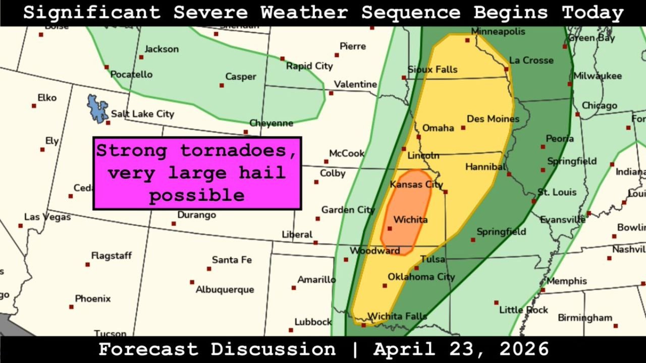
The most intense storm activity is expected to develop near a triple point in southern Kansas, extending southward along the dryline into Oklahoma. This type of setup is among the most favorable configurations for producing violent, long-track supercells. Additional convection is also anticipated along a frontal boundary to the north, expanding the threat zone.
The outlook map designates the area from Wichita and Woodward through Tulsa and Oklahoma City as the highest-risk corridor, marked in the enhanced to high risk zone.
Threat Zone at a Glance
| Risk Level | Areas Included |
|---|---|
| Highest Risk (orange/red zone) | Wichita, Woodward, Tulsa, Oklahoma City, Wichita Falls |
| Elevated Risk (yellow zone) | Kansas City, Lincoln, Omaha, Springfield, Evansville |
| Marginal Risk (green zone) | Des Moines, Sioux Falls, Memphis, Little Rock |
All Hazards on the Table
Forecasters have made clear that all severe weather hazards will be possible with today’s storms. Primary threats include:
- Strong tornadoes, including the potential for significant, long-track events
- Very large hail, potentially baseball-sized or larger
- Damaging straight-line winds
- Heavy rainfall and localized flash flooding
Additional Threat Continues Into Tomorrow
Today marks the beginning of a multi-day significant severe weather sequence. Forecasters have noted that tomorrow’s setup will also bring severe weather potential, meaning residents across the southern and central Plains should remain on alert through at least the next 48 hours.
Who Needs to Be Prepared Right Now
Anyone located from southern Kansas through central and eastern Oklahoma and into northern Texas is in the direct path of today’s most dangerous storms. Communities including Wichita, Woodward, Tulsa, Oklahoma City, and Wichita Falls face the most significant risk and should have multiple ways to receive warnings and a shelter plan in place immediately.
Do not wait for storms to develop before acting. Monitor conditions closely throughout the afternoon and evening. Stay with CabarrusWeekly.com for continuing coverage of this severe weather outbreak as it unfolds.