Oklahoma Severe Storm Threat Grows This Evening as Storms Fire Along the Dryline Near Sunset
OKLAHOMA — A conditional but significant severe weather threat is developing across Oklahoma this evening, April 23, 2026, as storms are forecast to ignite along the sharp dryline near sunset in a highly sheared and unstable atmospheric environment.
Convection Expected to Fire Near Sunset
Model guidance shows convection initiating across Oklahoma around sunset and into the early evening hours. The environment features approximately 35 knots of wind shear along the dryline, combined with ample instability — a setup that can support rotating thunderstorms once storms manage to break through the existing cap.
The closest historical analog to today’s setup is April 19th, 2023, a day with a nearly identical atmospheric profile. The key differences today are slightly warmer surface temperatures and a marginally weaker cap at the 12Z observation time — conditions that could ultimately make storm initiation more likely as the afternoon progresses.
A Strong Cap Is the Wild Card
The 12Z sounding out of Norman, Oklahoma shows a strong capping inversion in place — a layer of warm air aloft that is currently suppressing storm development. The critical question for this evening is whether that cap weakens sufficiently as daytime heating and the advancing dryline erode it through the afternoon hours.
If the cap breaks, storms that develop will have access to a deeply unstable environment with strong shear — a recipe for supercell development.
What the Atmospheric Data Shows
The Norman sounding reveals a loaded severe weather environment beneath the cap:
| Parameter | Value |
|---|---|
| Most Unstable CAPE | 2,903 m²/s² |
| Mixed-Layer CAPE | 2,011 m²/s² |
| CINH (cap strength) | -142 J/kg |
| Effective Shear | 33 knots |
| Effective SRH | 362 m²/s² |
| STP Fixed | 2.1 |
| Supercell Composite | 13.6 |
| Surface Relative Humidity | 90% |
| Max Temperature | 83°F |
The Significant Tornado Parameter of 2.1 and Supercell Composite of 13.6 place this event in the 40th to 45th and 55th to 60th climatological percentiles respectively for EF2-or-stronger tornado environments based on data from 2003 to 2024.
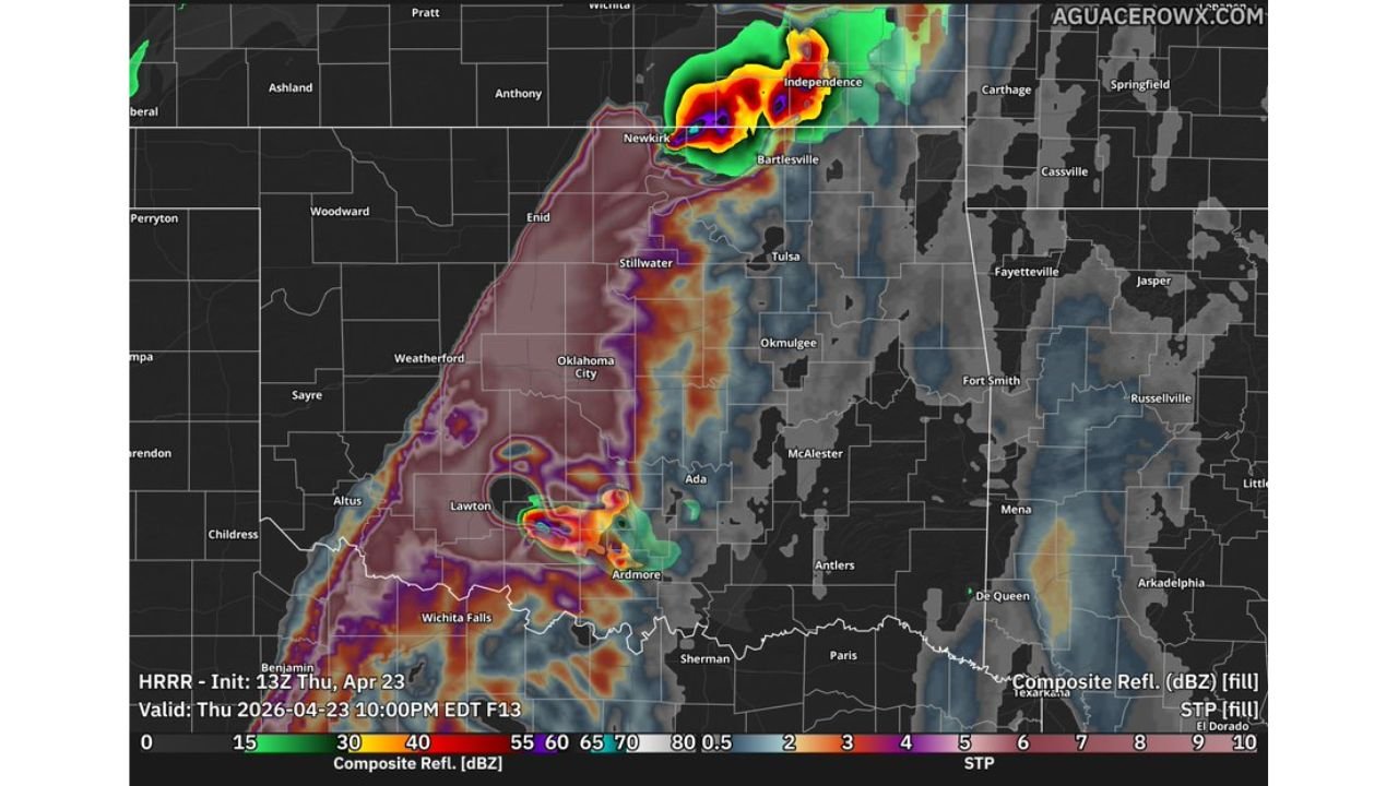
Radar Guidance Points to Northern Oklahoma and Kansas Border
Forecast radar guidance valid for 10:00 PM EDT this evening shows the most intense storm activity developing across northern Oklahoma near Newkirk and Bartlesville, pushing toward the Kansas border near Independence. A secondary area of convection is also indicated near Lawton and Ardmore in southern Oklahoma.
The storm tracks and STP values on the guidance map highlight the northern Oklahoma corridor as the primary area of concern for the most organized and potentially significant storm activity tonight.
Key Threats If Storms Develop
- Rotating supercells capable of producing tornadoes
- Large to very large hail
- Damaging wind gusts
- This remains a conditional threat — storm initiation depends on whether the cap weakens sufficiently
Residents across northern and central Oklahoma, including the Oklahoma City metro, Enid, Stillwater, Bartlesville, and areas near the Kansas border, should monitor conditions closely through the evening hours and have a shelter plan ready before sunset.
Stay with CabarrusWeekly.com for continuing coverage as this evening’s severe weather threat evolves.