Eastern Oklahoma Faces Another Conditional Strong Tornado Threat on Saturday April 26
EASTERN OKLAHOMA — The east side of Oklahoma is facing a conditional but significant tornado threat on Saturday, April 26, 2026, as a powerful atmospheric setup featuring very high instability, moderate to strong shear, and favorable boundary interactions could produce strong to violent tornadoes if storms manage to stay discrete and ride the boundary.
A Setup Built for Tall, Significant Tornadoes
Forecasters are highlighting this as a potential structure and tall tornado type day — a setup where tornadoes, if they develop, could be long-lived and visually significant. The key ingredients are all coming together across eastern Oklahoma:
Very high instability is in place, with the sounding data showing surface-based CAPE of 5,285 J/kg and most unstable CAPE of 4,795 J/kg — an exceptionally loaded environment. 3CAPE and surface vorticity values are also elevated, adding to the tornado potential.
Wind shear is moderate to strong, with effective bulk wind difference of 250/22 knots and strong turning with height confirmed in the hodograph. The critical angle is reading 93 degrees, a value associated with particularly tornado-favored environments.
The Cap and LCL Are the Key Uncertainties
The LCL is noted as high — meaning the cloud base will be elevated. This can sometimes reduce tornado intensity or longevity, though it does not eliminate the threat, especially given the magnitude of instability and shear in place.
A capping inversion remains present, and the threat remains conditional on whether storms can fire discretely and stay organized along the boundary rather than merging into a messy cluster. Forecasters will be watching closely over the next 24 hours for trends in convective initiation.
What the Atmospheric Data Shows
| Parameter | Value |
|---|---|
| Surface-Based CAPE | 5,285 J/kg |
| Most Unstable CAPE | 4,795 J/kg |
| Mixed-Layer CAPE | 1,029 J/kg |
| DCAPE | 1,123 J/kg |
| Effective Shear (EBWD) | 250/22 kt |
| Effective SRH | 316 m²/s² |
| STP (cin) | 8.8 |
| STP Fixed | 0.99 |
| Supercell Composite | 33.3 |
| Critical Angle | 93 degrees |
| Max Temperature | 88°F |
| Convective Temperature | 83°F |
The Supercell Composite of 33.3 is exceptionally high. The SARS analog database confirms a 100% supercell match and 93% significant hail match, with the probable hazard type flagged as TOR — tornado.
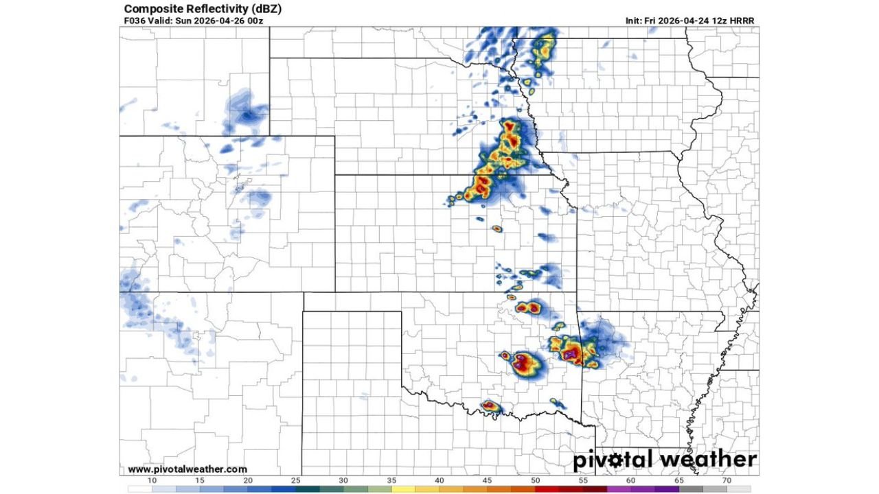
Forecast Radar Guidance for Saturday Night Into Sunday
Model guidance valid for Sunday April 26 at 00Z (Saturday evening local time) shows intense storm cells developing across eastern Oklahoma and pushing into western Arkansas and southern Kansas. The most intense reflectivity cores are depicted across the Kansas-Oklahoma border region and into eastern Oklahoma, with additional storm activity indicated further north across central Kansas.
Who Needs to Be Watching
Residents across eastern Oklahoma — including areas near the boundary zone — should be actively monitoring this developing threat through Friday and into Saturday. If storms initiate discretely and ride the boundary as forecast, the conditions are in place for EF2-or-stronger tornadoes, large hail, and damaging winds.
This is a fast-evolving setup and additional clarity is expected within the next 24 hours. Stay with CabarrusWeekly.com for continuing updates on the Saturday severe weather threat across eastern Oklahoma.