Texas to Maryland Face Isolated Damaging Winds, Large Hail and Tornado Threat Today as Spring Storm System Moves Through
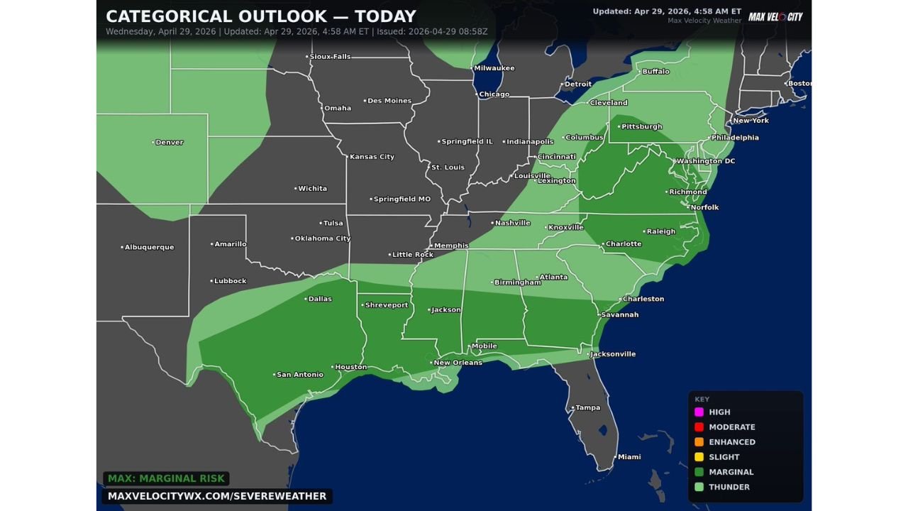
UNITED STATES — Severe weather is possible across a large corridor from Texas to Maryland on Wednesday, April 29, 2026, with isolated damaging winds, large hail, and a couple of tornadoes possible throughout the day. The Categorical Outlook, updated at 4:58 AM ET, shows the maximum risk level at Marginal Risk across the affected zone.
How Wide the Threat Zone Stretches Today
The storm threat covers an expansive area across the South, Southeast, and Mid-Atlantic. The Marginal Risk zone stretches from Texas and San Antonio in the southwest through Dallas, Shreveport, Little Rock, Memphis, Jackson, Mobile, New Orleans, Nashville, Birmingham, Atlanta, Charlotte, Raleigh, Richmond, Washington D.C., and into Maryland.
A broader general thunderstorm zone extends even further, reaching northward through St. Louis, Indianapolis, Louisville, Columbus, Pittsburgh, Philadelphia, and New York.
What Type of Storms to Expect
These storms are described as typical spring variety severe storms — not an extreme or highly organized outbreak. Residents across the affected corridor should remain weather aware but the overall threat is not expected to be widespread or particularly intense across most areas.
Hazards possible with the stronger storms include:
- Isolated damaging winds
- Large hail
- A couple of tornadoes possible
The Cities Most Directly in the Risk Zone
The Marginal Risk area covers a broad swath of the South and Southeast. Key cities sitting within the outlined threat zone include:
San Antonio, Houston, Dallas, Lubbock, Amarillo, Tulsa, Oklahoma City, Little Rock, Memphis, Shreveport, Jackson, New Orleans, Mobile, Nashville, Birmingham, Atlanta, Charlotte, Raleigh, Charleston, Savannah, Jacksonville, Tampa, Richmond, Norfolk, Washington D.C., and Maryland.
Timing and Awareness for Wednesday
The outlook is valid for Wednesday, April 29, 2026 and covers the full day through this evening. While most storms will remain below severe limits, the isolated hazards of damaging wind, hail, and tornadoes are enough to warrant staying weather aware across the entire corridor from Texas to Maryland throughout the day.
Stay with CabarrusWeekly.com for continuing updates as this spring storm system pushes through the region today.