Carolinas and Piedmont Watch for Isolated Strong Storms This Afternoon as Sunshine and Instability Become the Key Factors
NORTH CAROLINA / SOUTH CAROLINA — Rain chances were minimal across the Carolinas this morning, but the focus now shifts to this afternoon as isolated storm development becomes possible across the region. Widespread storms are not expected, but one to two isolated storms with a few strong ones could develop depending on how much sunshine and instability build through the afternoon hours on Wednesday, April 29, 2026.
Widespread Storms Not Expected But Isolated Threat Remains
The chances of anything widespread developing are described as close to zero. However, one to two isolated storms are possible, with a few of those carrying the potential to become strong. The entire setup hinges on sunshine breaking through and building instability across the region during the afternoon.
More substantial rainfall chances are not expected until Friday morning or Saturday morning at the earliest.
The Main Risk This Afternoon
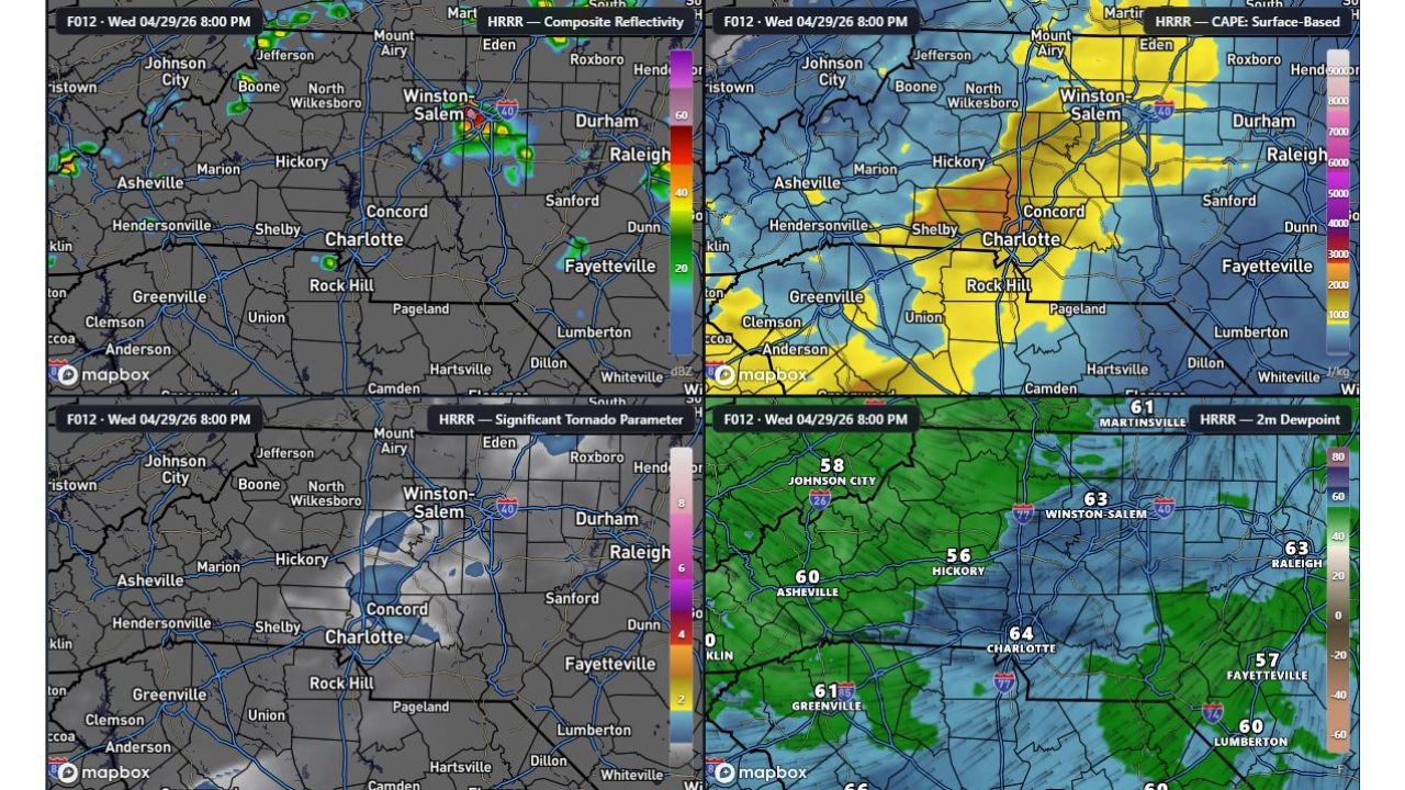
The primary hazard associated with any storms that do develop is a 15 percent chance of strong winds. While the tornado parameter data shown on HRRR valid Wednesday, April 29, 2026 at 8:00 PM remains very low across the region, the CAPE surface-based data shows elevated instability values across a broad area including Charlotte, Winston-Salem, Hickory, Raleigh, and surrounding communities, providing enough fuel for isolated strong storm development if sunshine can erode cloud cover this afternoon.
Dewpoint and Moisture Readings Across the Region
HRRR 2-meter dewpoint data valid Wednesday, April 29, 2026 at 8:00 PM shows the following readings across key locations:
- Martinsville: 61
- Johnson City: 58
- Winston-Salem: 63
- Hickory: 56
- Asheville: 60
- Charlotte: 64
- Greenville: 61
- Raleigh: 63
- Fayetteville: 57
- Lumberton: 60
The moisture in place is sufficient to support convection if daytime heating can destabilize the atmosphere enough through the afternoon hours.
Cities and Areas to Watch This Afternoon
Based on the radar and instability data, the areas to monitor most closely for isolated afternoon storm development include Winston-Salem, Charlotte, Concord, Hickory, Raleigh, Durham, Fayetteville, Rock Hill, and the surrounding Piedmont communities.
When More Rain Arrives
For those waiting on more meaningful and widespread rainfall, the outlook points toward Friday morning or Saturday morning as the next opportunity for more substantial precipitation across the Carolinas.
Stay with CabarrusWeekly.com for continuing updates as afternoon storm chances develop across the Carolinas today.