Severe Threat Upgraded Wednesday as Two Slight Risks Added Across South Central US and East Coast for Hail and Damaging Winds
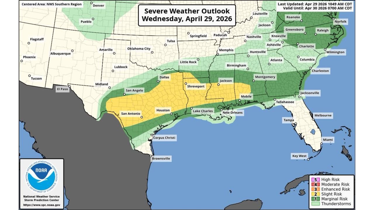
UNITED STATES — The severe weather threat for Wednesday, April 29, 2026 has been upgraded, with two Slight Risk zones now added to the outlook. One covers the south central United States for significant hail potential, and a second targets the East Coast for damaging wind potential. The outlook was last updated at 10:49 AM CDT and is valid through April 30, 2026 at 7:00 AM CDT.
Two Slight Risks Now in Place
The upgraded outlook from the National Weather Service Storm Prediction Center now shows:
Slight Risk — South Central US: Covering a broad zone from San Antonio, Houston, Dallas, Shreveport, Jackson, Lake Charles, New Orleans, and Mobile, this zone carries the primary threat of significant hail potential today.
Slight Risk — East Coast: A separate Slight Risk zone stretches along the East Coast corridor targeting damaging wind potential, covering areas including Roanoke, Greensboro, Raleigh, Charlotte, Wilmington, Columbia, Charleston, and Jacksonville.
Tornado Threat Remains Low But Spinups Possible
While the tornado threat remains at the Marginal Risk level, forecasters note that a few tornado spinups are possible across the affected area today. The broader Marginal Risk zone covers a wide corridor from Texas through the Gulf states, the Southeast, Tennessee Valley, and into the Mid-Atlantic, including Little Rock, Memphis, Birmingham, Huntsville, Atlanta, Montgomery, Nashville, Knoxville, Asheville, and Charlotte.
Full Hazard Breakdown for Wednesday
- Significant hail — south central US from Texas through the Gulf Coast
- Damaging winds — East Coast corridor
- A few tornado spinups possible — marginal threat across the broader zone
- General thunderstorm activity — widespread across the South and Southeast
The Broader Risk Zone
Beyond the two Slight Risk areas, a Marginal Risk zone extends across a massive portion of the South and East, and a general thunderstorm zone pushes even further north and east toward the Ohio Valley and Mid-Atlantic. Cities across this wider zone including Tulsa, Oklahoma City, Springfield, Paducah, Louisville, and Knoxville remain in the general severe weather corridor for the day.
Stay with CabarrusWeekly.com for continuing updates as this upgraded severe weather outbreak develops across the South and East Coast today.