Central United States Precipitation Outlook Flips From Wet to Much Drier for May 5 Through June 5 as 30-Day Forecast Undergoes Major Change
CENTRAL UNITED STATES — A significant shift has occurred in the 30-day precipitation outlook for the Central United States. The forecast valid through June 5, 2026 has flipped dramatically over the past ten days, moving from a wetter than normal signal to a much drier pattern across a broad swath of the central and western United States.
What the Forecast Looked Like Ten Days Ago
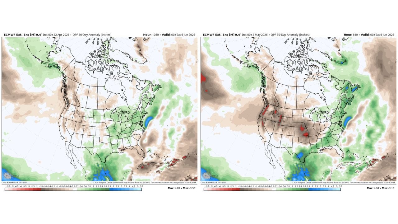
The 30-day QPF anomaly forecast initialized on April 22, 2026 showed the Central and Eastern United States trending above normal for precipitation through early June. Green shading dominated the Midwest, Great Plains, and much of the East, with above normal anomalies extending across a wide corridor. The maximum anomaly on that run reached positive 4.89 inches above the 1991 to 2020 climatological average.
What the Current Forecast Shows Now
The updated 30-day outlook initialized on May 2, 2026 tells a completely different story. The green wet signal across the Central United States has been replaced by brown and tan dry anomaly shading, covering the Central and Southern Plains, the Rockies, the Southwest, and large portions of the Midwest. The minimum anomaly on the current run sits at negative 3.15 inches below normal across the most affected areas.
Where Dryness Is Now Expected May 5 Through June 5
| Region | Current Signal | Change From 10 Days Ago |
|---|---|---|
| Central and Southern Plains | Below normal, dry | Flipped from above normal |
| Rockies and Southwest | Below normal, dry | Continued and expanded dry signal |
| Midwest | Near to below normal | Flipped from above normal |
| Northeast and Mid-Atlantic | Near to slightly above normal | Largely unchanged |
| Gulf Coast and Southeast | Near to slightly above normal | Minor wet signal retained |
Pacific Northwest Retains Some Wet Signal
While the Central United States has shifted dramatically drier, portions of the Pacific Northwest continue to show a near normal to slightly above normal precipitation signal on the current run, consistent with the previous forecast. This region was not part of the major forecast flip.
The change in the 30-day outlook represents a significant development for drought and agricultural interests across the Central Plains and Rockies heading into late spring.
Stay with CabarrusWeekly.com for continuing updates on the May through June precipitation outlook across the Central United States.