Ohio, Indiana, Kentucky and Tennessee Face 50 to 99mm of Rainfall Next Week With Great Lakes Region Seeing Lighter Totals Through Saturday May 9
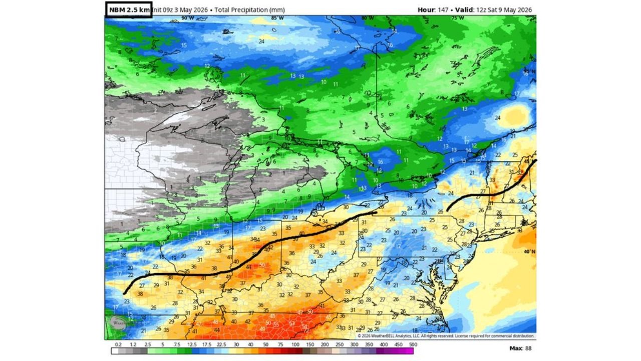
OHIO, INDIANA, KENTUCKY AND TENNESSEE — Ensemble rainfall guidance valid through Saturday, May 9, 2026 shows a significant precipitation gradient setting up across the Great Lakes region and surrounding states next week, with the heaviest totals of 50 to 99mm concentrated across Ohio, Indiana, Kentucky and Tennessee while areas north of the Great Lakes receive considerably lighter amounts.
Southern Ohio, Kentucky and Tennessee Face the Heaviest Rain
All three guidance runs valid through 12Z Saturday, May 9 are in strong agreement that the heaviest rainfall totals next week will fall across a corridor from southern Indiana and Ohio through Kentucky and Tennessee. The orange and red shading on all three maps indicates totals in the 40 to 99mm range across this zone, with the NBM showing isolated areas reaching up to 88mm and the WPC guidance peaking at 99mm across portions of Kentucky and Tennessee.
Red and deep orange values on the WPC run are concentrated across southern Kentucky, central Tennessee and the Ohio River valley corridor, suggesting this area carries the highest rainfall potential of the week ahead.
Great Lakes Region Receives Lighter but Meaningful Totals
Areas directly around and north of the Great Lakes — including Michigan, Wisconsin and northern Indiana — are forecast to receive 5 to 20mm of precipitation through Saturday. The green shading across this zone is consistent across all guidance runs, indicating light to moderate rainfall rather than the heavier totals expected farther south.
Multi-Model Rainfall Comparison Through May 9
| Region | NBM | WPC | ECMWF Ensemble | CMC Ensemble |
|---|---|---|---|---|
| Southern KY and TN | 50 to 88mm | 57 to 99mm | 42 to 54mm | 36 to 63mm |
| Ohio and Indiana | 30 to 50mm | 29 to 44mm | 29 to 43mm | 28 to 37mm |
| Great Lakes zone | 5 to 19mm | 6 to 18mm | 4 to 17mm | 3 to 14mm |
| Northeast corridor | 19 to 34mm | 15 to 36mm | 22 to 43mm | 18 to 35mm |
These Are Ensemble Mean Values
As noted in the forecast discussion, these totals represent ensemble mean values across multiple model runs. Individual locations may see more or less than the values shown depending on storm track and timing as the week develops. The mean values provide a reliable overall guide for the week ahead.
Stay with CabarrusWeekly.com for daily rainfall forecast updates across the Great Lakes, Ohio Valley and Tennessee through Saturday May 9.