Central Florida Did Not Expect This in May — A Heat Dome Is Pushing Orlando Toward Record Temperatures on Thursday
CENTRAL FLORIDA — A heat dome sliding in from the Gulf is setting the stage for a potentially record-breaking day across central Florida on Thursday, May 7, 2026, with temperatures in the upper 90s possible around Orlando nearly a full month earlier than typically expected.
Nearly a Month Too Early for This Kind of Heat
The average first day of 96 degrees or hotter in central Florida is June 6th. Thursday’s forecast puts the region on track to shatter that benchmark by almost a full month, making this an historically early and significant heat event for the area.
What the Jet Stream Is Doing
The jet stream forecast for Thursday, May 7 shows a heat dome positioned directly over the Gulf region with Orlando sitting squarely inside the core of the heat. The circulation pattern is trapping hot air across central Florida with no meaningful relief in sight for the day.
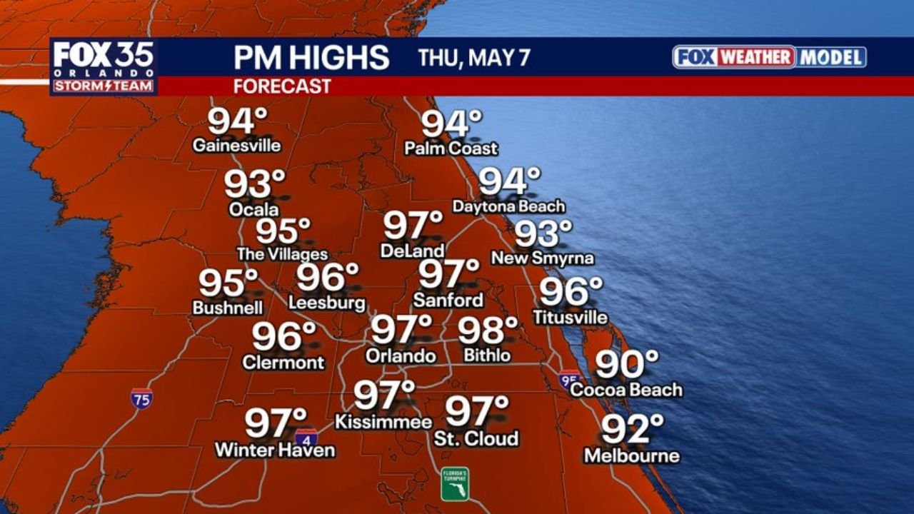
Afternoon High Temperatures Thursday May 7
| City | Forecast High |
|---|---|
| Bithlo | 98°F |
| Orlando | 97°F |
| Kissimmee | 97°F |
| St. Cloud | 97°F |
| Winter Haven | 97°F |
| DeLand | 97°F |
| Sanford | 97°F |
| Leesburg | 96°F |
| Clermont | 96°F |
| Titusville | 96°F |
| Daytona Beach | 94°F |
| Gainesville | 94°F |
| Palm Coast | 94°F |
| The Villages | 95°F |
| Bushnell | 95°F |
| Ocala | 93°F |
| New Smyrna | 93°F |
| Melbourne | 92°F |
| Cocoa Beach | 90°F |
The Hottest Spots to Watch Thursday
Bithlo leads the forecast at 98 degrees, followed closely by Orlando, Kissimmee, St. Cloud, Winter Haven, DeLand, and Sanford all hitting 97 degrees during the afternoon hours. The heat is widespread across the entire central Florida region with no city escaping the upper 90s in the interior.
What This Means for Residents
Temperatures of this magnitude in early May carry serious health risks. Residents across Orlando, Kissimmee, Sanford, and surrounding communities should limit outdoor exposure during peak afternoon hours, stay hydrated, and never leave children or pets inside vehicles.
The combination of a Gulf-driven heat dome and jet stream positioning makes Thursday a day to take seriously across all of central Florida.
Stay with CabarrusWeekly.com for continuing updates on the central Florida heat event through Thursday.