Washington, Oregon, California, and the Pacific Northwest Face Dangerous Heat and Severe Drought From May Through July 2026
WESTERN UNITED STATES — The European Centre for Medium-Range Weather Forecasts is signaling a troubling combination for the western United States this summer: well-below-normal precipitation and well-above-normal temperatures are both projected to dominate from May through July 2026.
A Drier-Than-Normal Pattern Takes Hold Across the West
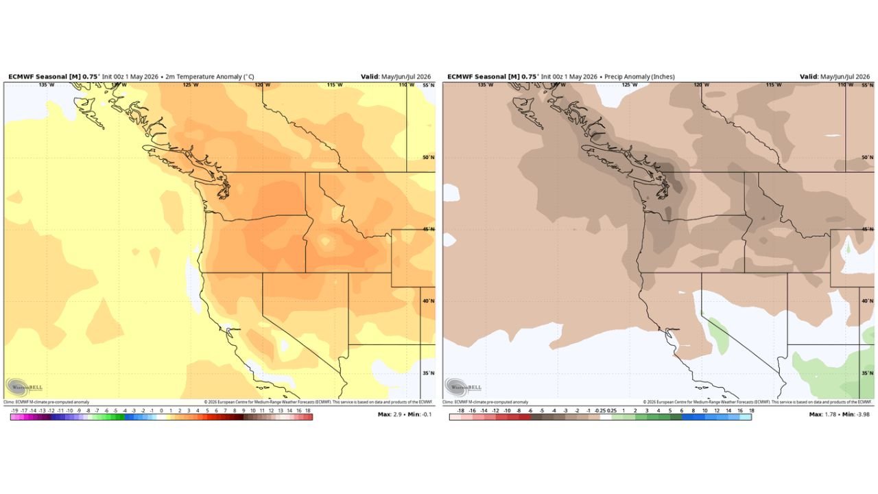
The ECMWF seasonal forecast, initialized on May 1, 2026, shows a broad and persistent precipitation deficit stretching across much of the western United States and into southwestern Canada. The anomaly map indicates negative precipitation departures shown in brown covering the Pacific Northwest, California, the Great Basin, and surrounding regions.
The most pronounced dryness is focused along the Pacific Coast corridor, including coastal British Columbia, Washington, and Oregon, where anomalies reach as deep as -3.98 inches below normal for the three-month period.
Temperatures Running Well Above Normal From Coast to Interior
Alongside the dryness, the temperature anomaly map tells an equally concerning story. A warm to very warm signal blankets the entire western region, with 2-meter temperature anomalies reaching as high as +2.9°C above normal at the peak.
The strongest heat signal is concentrated across the interior Pacific Northwest, the northern Rockies, and the northern Great Basin, with above-normal warmth extending south through California and east across the broader region. Only the far southern fringe shows any approach toward near-normal readings.
A Three-Month Window of Heat and Dryness
This is not a short-duration event. The ECMWF seasonal model projects the combined heat and drought signal to persist across the full May, June, and July window, a sustained three-month period of anomalous warmth and precipitation deficit.
| Signal | Direction | Peak Anomaly |
|---|---|---|
| Precipitation | Well Below Normal | -3.98 inches |
| Temperature | Well Above Normal | +2.9°C |
| Valid Period | May / June / July 2026 |
Fire and Drought Risks Loom Large This Season
The combination of below-normal rainfall and above-normal heat creates elevated wildfire and drought conditions across the West. The pattern mirrors the classic setup for an active fire season: dry fuels, warm temperatures, and a multi-month window for conditions to intensify.
Areas of particular concern based on the maps include:
- Coastal and interior Pacific Northwest — deepest precipitation deficits
- Northern Rockies and Great Basin — strongest combined heat and dryness signal
- California — broad area of below-normal precipitation alongside above-normal warmth
What the Outlook Means Going Forward
The ECMWF seasonal model carries meaningful uncertainty at this range, but the consistency of both signals, heat and dryness together, across a wide region, for three full months, warrants close attention. Land managers, fire agencies, and water resource managers across the western states should treat this outlook as an early indicator of a potentially difficult summer ahead.
Stay with CabarrusWeekly.com for continued updates as the summer pattern evolves and more model guidance becomes available.